50 Almond St, Staten Island, NY 10312 Richmond County Last Updated: February 28, 2024
Pre-Foreclosure: Lis Pendens, Estimated Market Value $1,296,000
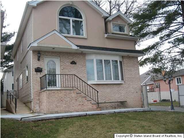
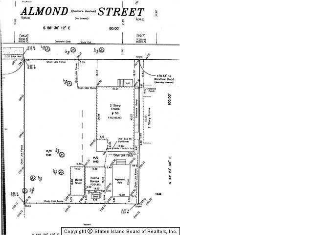
Description: 50 Almond St, Staten Island, NY 10312 is a Single Family Home built in 1945. This property was last sold for $585,000 in 2013 and currently has an estimated value of $1,296,000. According to the Staten Island public records, the property at 50 Almond St, Staten Island, NY 10312 has approximately 2,124 square feet, with a lot size of 8,000 square feet. Nearby schools include Ps 4 Maurice Wollin, Ps 42 Eltingville and Ps 36 J C Drumgoole.
2,124 sqft
8,000 lot size
Year Built: 1945
Pre-foreclosure
50 Almond St, Staten Island, NY 10312
Last Updated: February 28, 2024
2
Single Family Home
Town House
Estimated Market Value EMV $ 1,296,000
50 Almond St
bool(false)

bool(true)

bool(true)

int(0)
Estimated Market Value EMV $ 1,296,000
Foreclosure History
for 50 Almond St
for 50 Almond St
Type
Single Family Home
Town House
50 Almond St, Staten Island, NY 10312 is a Single Family Home built in 1945. This property was last sold for $585,000 in 2013 and currently has an estimated value of $1,296,000. According to the Staten Island public records, the property at 50 Almond St, Staten Island, NY 10312 has approximately 2,124 square feet, with a lot size of 8,000 square feet. Nearby schools include Ps 4 Maurice Wollin, Ps 42 Eltingville and Ps 36 J C Drumgoole.
Property features
Year Built:
Year Built:
1945
1945
Living Area:
Living Area:
2124
2124
Building Class:
A1
One Family Dwellings: Two Stories Detached (Small Or Moderate Size, With Or Without Attic)
Floors on Main Building:
2
Building Dimensions:
25'
Actual Square Footage:
2,124
Calculated Square Footage:
2,100
Residential Floor Area:
2,124
Basement:
Below grade full basement
Address:
50 ALMOND STREET
Borough:
Staten Island (5)
Land Use:
01
One & Two Family Buildings
Calculated Lot Perimeter:
364.44 ft
Zoning Districts:
R3X
Lower-density residence district
Special Purpose Districts:
SRD
Special South Richmond Development District
Max Residential FAR:
0.50
Max Residential Sqft:
4,000
Buildable Residential Sqft:
1,876
Residential Area Distribution:
Assessed Land Value:
$21,180
Assessed Total Value:
$47,940
Exempt Total Value:
$3,800
Last Recording Date:
Jan 8, 2024
Property Assessment Data:
Tax Class:
1
One- to three-unit residential properties
Taxable Assessed Value:
$38,022
Estimated Market Value by NYC DOF :
$864,000
Community District (CD):
503
City Council District:
51
Document DateDocument Type Unit Amount
Date
Event
Price
Price/Sqft
Source
Dec 19, 2019
Listing removed
$589,000
$277
StatenIsland
Sep 16, 2013
Sold
$585,000
$275
Public Record
Aug 6, 2013
Sold
$585,000
$275
StatenIsland
Jun 10, 2013
Listing removed
$599,000
—
StatenIsland
Feb 28, 2013
Price Changed
$588,000
$277
StatenIsland
Nov 8, 2012
Price Changed
$595,000
$280
StatenIsland
Sep 4, 2012
Listed
$599,000
—
StatenIsland
Aug 17, 2012
Price Changed
$599,000
$282
StatenIsland
Aug 6, 2012
Price Changed
$610,000
$287
StatenIsland
Jul 19, 2012
Price Changed
$612,500
$288
StatenIsland
Apr 24, 2012
Price Changed
$615,000
$290
StatenIsland
Feb 23, 2012
Listed
$619,000
$291
StatenIsland
Nov 3, 2011
Listing removed
$589,000
$277
StatenIsland
Sep 27, 2011
Price Changed
$589,000
$277
StatenIsland
Sep 8, 2011
Price Changed
$599,900
$282
StatenIsland
Jul 25, 2011
Price Changed
$609,000
$287
StatenIsland
Jul 20, 2011
Price Changed
$599,900
$282
StatenIsland
Jun 15, 2011
Price Changed
$629,900
$297
StatenIsland
Jun 1, 2011
Price Changed
$659,000
$310
StatenIsland
May 11, 2011
Price Changed
$679,500
$320
StatenIsland
May 4, 2011
Listed
$689,500
$325
StatenIsland
Sep 17, 1993
Sold
$156,000
$73
Public Record
Dec 2, 1986
Sold
$140,000
$66
Public Record
Year
Taxes
Land
Additions
Total Assessment
2022
$6,001
$21,180
$26,220
$47,400
2021
$6,366
$21,180
$19,620
$40,800
2020
$7,160
$21,180
$20,880
$42,060
2019
$6,631
$21,180
$20,760
$41,940
2018
$6,572
$21,180
$11,700
$32,880
2017
$7,112
$21,180
$15,180
$36,360
2016
$7,210
$21,180
$16,440
$37,620
2015
$6,730
$17,640
$18,360
$36,000
2014
$6,548
$15,549
$21,315
$36,864
2014
$6,419
$16,735
$21,972
$38,707
2012
$6,418
$17,224
$19,640
$36,864
2010
$5,655
$17,054
$19,187
$36,241
2009
$5,276
$19,435
$14,755
$34,190
2007
$4,542
$6,752
$23,968
$30,720
Address
Price
Built
Beds
Baths
Sqft
Lot Size
Distance
136 Ellsworth Ave
Staten Island, NY 10312SF
$900,000
12/07/2023
1970
3
3
2,133
+9difference
4,560
0.87 mi
131 Delmar Ave
Staten Island, NY 10312SF
$825,000
02/20/2024
1980
3
3
2,070
-54
4,000
0.44 mi
22 Deserre Ave
Staten Island, NY 10312SF
$690,000
12/27/2023
1977
3
2
2,232
+108
5,945
0.82 mi
137 N Pine Ter
Staten Island, NY 10312SF
$650,000
02/23/2024
1965
4
2
2,008
-116
4,720
0.95 mi
133 N Pine Ter
Staten Island, NY 10312SF
$805,000
12/11/2023
1965
3
2
2,008
-116
5,500
0.96 mi
397 Arden Ave
Staten Island, NY 10312SF
$750,000
02/16/2024
1960
3
3
1,200
-924
7,040
0.11 mi
225 Crown Ave
Staten Island, NY 10312SF
$1,185,000
10/25/2023
1980
4
4
3,698
+1,574
9,600
0.14 mi
131 Correll Ave
Staten Island, NY 10312SF
$799,000
12/06/2023
1985
3
2
2,279
+155
4,880
0.17 mi
139 Vespa Ave
Staten Island, NY 10312SF
$685,000
12/21/2023
1987
3
3
1,902
-222
2,542
0.19 mi
47 Manchester Dr
Staten Island, NY 10312SF
$730,000
02/28/2024
1980
3
3
1,914
-210
2,914
0.22 mi
Address
Price
Built
Beds
Baths
Sqft
Lot Size
Distance
327 Getz Ave
Staten Island, NY 10312SF
$669,999
97 days ago
1984
3
2
2,115
-9difference
3,240
1.33 mi
47 Marne Ave
Staten Island, NY 10312SF
$849,999
14 days ago
1990
4
4
2,112
-12
2,500
0.87 mi
20 Marvin Rd
Staten Island, NY 10309SF
$799,713
56 days ago
1980
3
2
2,104
-20
4,000
1.71 mi
20 Gabriele Ct
Staten Island, NY 10312SF
$880,000
86 days ago
2004
3
4
2,100
-24
5,358
1.21 mi
59 Ladd Ave
Staten Island, NY 10312SF
$849,999
59 days ago
1975
4
4
2,088
-36
3,700
1.13 mi
61 Middle Loop Rd
Staten Island, NY 10308SF
$749,000
31 days ago
1970
4
2
2,080
-44
2,800
1.48 mi
40 Chesebrough St
Staten Island, NY 10312SF
$529,888
62 days ago
1992
2
2
2,176
+52
1,400
1.19 mi
40 Chesebrough St
Staten Island, NY 10312SF
$529,888
62 days ago
1992
2
2
2,176
+52
1,400
1.19 mi
131 Vespa Ave
Staten Island, NY 10312SF
$769,000
38 days ago
1986
3
3
2,052
-72
2,753
0.17 mi
415 Ramona Ave
Staten Island, NY 10312SF
$874,900
22 days ago
1977
3
2
2,038
-86
4,410
0.95 mi
Estimated values are not a substitute for professional expertise. Contact your RE agent for a market assessment.
School Name
Rating
Grades
Parent Rating
Distance
Ps 4 Maurice Wollin
, Staten Island , NY 10312
8 / 10
K−5
0.32 mi
Is 75 Frank D Paulo
, Staten Island , NY 10312
8 / 10
6−8
0.55 mi
Ps 42 Eltingville
, Staten Island , NY 10312
7 / 10
K−5
1.08 mi
Ps 36 J C Drumgoole
, Staten Island , NY 10312
8 / 10
K−5
0.62 mi
Oakdale Academy
, Staten Island , NY 10312
—
K−1
1.57 mi
Our Lady Star of the Sea
, Staten Island , NY 10312
—
PK−8
1.18 mi
Tottenville High School
, Staten Island , NY 10312
6 / 10
9−12
1.55 mi
Eltingville Lutheran School
, Staten Island , NY 10312
—
PK−7
1.25 mi
Lois And Richard Nicotra Early Colle
, Staten Island , NY 10312
2 / 10
8−11
1.24 mi
Is 7 Elias Bernstein
, Staten Island , NY 10312
8 / 10
6−8
1.86 mi
FEMA Zone (Est.)
X (unshaded)
Flood insurance:
Recommended
Flood risks are increasing as sea levels rise and weather patterns change.
This property has a
Minimal Flood Factor
.
Please Log In
Please wait... If this message is not eventually replaced by the proper contents of the document, your PDF viewer may not be able to display this type of document.
You can upgrade to the latest version of Adobe Reader for Windows®, Mac, or Linux® by visiting
https://get.adobe.com/reader/ this link .
For more assistance with Adobe Reader visit
http://get.adobe.com/reader/ this link .
You can download this PDF-document from
here .