
bool(false)

bool(true)

bool(true)

int(0)
Brooklyn, NY 11223
Property details
The description and property data below may have been provided by a third party, the homeowner or public records.
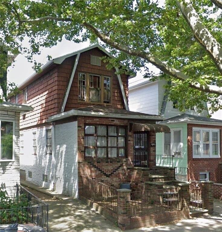
Prime Gravesend location! This detached, single-family property on a 20 x 100 lot is the perfect chance to customize how you like! While in need of TLC, the home, with 1, 400 sqft. of living space, boasts hardwood and tile floors, three spacious bedrooms on the second floor with plenty of closet and storage space, a full, unfinished basement, back and front yards, and a shared driveway with parking for one car. Amenities include quick and easy access to the multitude of establishments along McDonald Avenue, Avenue P, and 65th Street, P.S. 177, The Dahill Triangle, The Colonel David Marcus Playground, and much more! Transportation options include immediate access to the Avenue P 'M' Train station and Ocean Pkwy.
Primary Land Use and Tax Lot Information
for 1632 W 4th St

Real Property Records
for 1632 W 4th St | Document Type | |||
|---|---|---|---|
Property Price History
for 1632 W 4th St
| Date | Event | Price | ||
|---|---|---|---|---|
| Mar 27, 2024 | Listed | $928,000 | $663 | Brooklyn |
Property Tax History
for 1632 W 4th St
| Year | Taxes | |
|---|---|---|
| 2022 | $6,608 | $58,440 |
| 2021 | $6,828 | $51,960 |
Sold Homes
near 1632 W 4th St
| Address | Price | Beds | Baths |
|---|---|---|---|
|
Brooklyn, NY 11223SF
|
$930,000
03/11/2024
|
4
|
4
|
|
Brooklyn, NY 11204SF
|
$1,100,000
12/11/2023
|
3
|
3
|
|
Brooklyn, NY 11204SF
|
$1,060,000
03/15/2024
|
3
|
3
|
|
Brooklyn, NY 11204SF
|
$950,000
03/18/2024
|
4
|
2
|
|
Brooklyn, NY 11223SF
|
$950,000
11/22/2023
|
—
|
—
|
Homes For Sale
near 1632 W 4th St
| Address | Price | Beds | Baths |
|---|---|---|---|
|
Brooklyn, NY 11214SF
|
$1,080,000
33 days ago
|
4
|
3
|
|
Brooklyn, NY 11214SF
|
$1,080,000
33 days ago
|
4
|
3
|
|
Brooklyn, NY 11214SF
|
$1,288,000
50 days ago
|
4
|
2
|
|
Brooklyn, NY 11228SF
|
$1,220,000
74 days ago
|
3
|
2
|
|
Brooklyn, NY 11223SF
|
$1,300,000
85 days ago
|
3
|
2
|
Schools
serving 1632 W 4th St
| School Name | Rating |
|---|---|
|
346 AVE P, Brooklyn, NY 11204
|
7 / 10 |
|
2130 McDonald Avenue, Brooklyn, NY 11223
|
— |
|
1400 W 6th St, Brooklyn, NY 11204
|
— |
Data provided by
GreatSchools.org © 2024. All Rights Reserved.
School service boundaries are intended to be used as reference only.
To verify enrollment eligibility for a property, contact the school directly.
Flood Factor
for 1632 W 4th St
1
|10
Minimal

FEMA Zone (Est.)
X (unshaded)
Flood insurance:
Recommended
Flood risks are increasing as sea levels rise and weather patterns change.
This property has a
Minimal Flood Factor
.
Although flood risks across the country are changing because of the environment, this property is unlikely to flood over the next 30 years.
Although flood risks across the country are changing because of the environment, this property is unlikely to flood over the next 30 years.
Flood Factor data provided by FloodFactor.