130-57 224th St, Springfield Gardens, NY 11413 Queens County Last Updated: March 6, 2024
Pre-Foreclosure: Lis Pendens, Estimated Market Value $627,400
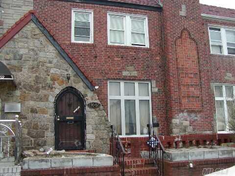
Description: 130-57 224th St, Springfield Gardens, NY 11413 is a Single Family Home built in 1935. This property was last sold for $325,000 in 2011 and currently has an estimated value of $627,400. According to the Springfield Gardens public records, the property at 130-57 224th St, Springfield Gardens, NY 11413 has approximately 1,400 square feet, with a lot size of 2,000 square feet. Nearby schools include Ps 132 Ralph Bunche and The Gordon Parks School.
1,400 sqft
2,000 lot size
Year Built: 1935
Pre-foreclosure
130-57 224th St, Springfield Gardens, NY 11413
Last Updated: March 6, 2024
1
Single Family Home
Town House
Estimated Market Value EMV $ 627,400
130-57 224th St
bool(false)

bool(true)

bool(true)

int(0)
Estimated Market Value EMV $ 627,400
Springfield Gardens, NY 11413
Foreclosure History
for 130-57 224th St
for 130-57 224th St
Type
Single Family Home
Town House
130-57 224th St, Springfield Gardens, NY 11413 is a Single Family Home built in 1935. This property was last sold for $325,000 in 2011 and currently has an estimated value of $627,400. According to the Springfield Gardens public records, the property at 130-57 224th St, Springfield Gardens, NY 11413 has approximately 1,400 square feet, with a lot size of 2,000 square feet. Nearby schools include Ps 132 Ralph Bunche and The Gordon Parks School.
Property features
Year Built:
Year Built:
1935
1935
Living Area:
Living Area:
1400
1400
Building Class:
A5
One Family Dwellings: Attached Or Semi-detached
Floors on Main Building:
2
Building Dimensions:
20'
Actual Square Footage:
1,400
Calculated Square Footage:
1,360
Residential Floor Area:
1,400
Basement:
Below grade full basement
Address:
130-57 224 STREET
Land Use:
01
One & Two Family Buildings
Calculated Lot Perimeter:
238.52 ft
Zoning Districts:
R4B
Lower-density residence district
Max Residential FAR:
0.90
Max Residential Sqft:
1,800
Buildable Residential Sqft:
400
Residential Area Distribution:
Assessed Land Value:
$10,860
Assessed Total Value:
$35,580
Last Recording Date:
Jan 8, 2024
Property Assessment Data:
Tax Class:
1
One- to three-unit residential properties
Taxable Assessed Value:
$30,499
Estimated Market Value by NYC DOF :
$593,000
Community District (CD):
413
City Council District:
31
Document DateDocument Type Unit Amount
Date
Event
Price
Price/Sqft
Source
Aug 18, 2011
Sold
$325,000
$239
Brooklyn
Nov 11, 2010
Sold
$350,000
—
OneKeyMLS
Jul 2, 2010
Price Changed
$359,990
—
OneKeyMLS
Jan 15, 2010
Listed
$389,990
—
OneKeyMLS
Aug 12, 2008
Sold
$325,000
$232
Public Record
Jul 24, 2008
Listed
$395,000
$290
Brooklyn
Dec 12, 1995
Sold
$128,000
$91
Public Record
Year
Taxes
Land
Additions
Total Assessment
2022
$5,637
$10,860
$23,340
$34,200
2021
$5,606
$10,860
$20,280
$31,140
2020
$5,379
$10,860
$16,140
$27,000
2019
$5,316
$10,860
$18,900
$29,760
2018
$5,145
$9,700
$14,898
$24,598
2017
$4,796
$10,165
$13,367
$23,532
2016
$4,438
$10,860
$11,340
$22,200
2015
$4,142
$12,060
$9,120
$21,180
2014
$4,057
$12,060
$9,120
$21,180
2013
$3,933
$11,319
$9,180
$20,499
2011
$3,307
$10,997
$9,192
$20,189
2010
$2,794
$10,209
$8,838
$19,047
2009
$2,835
$10,500
$7,471
$17,971
2007
$2,397
$2,506
$14,319
$16,825
Address
Price
Built
Beds
Baths
Sqft
Lot Size
Distance
242-10 131st Ave
Rosedale, NY 11422SF
$729,999
11/03/2023
1950
4
3
1,408
+8difference
4,000
0.79 mi
193-06 122nd Ave
Jamaica, NY 11413SF
$765,000
04/01/2024
1930
5
3
1,428
+28
4,059
0.62 mi
137-01 232nd St
Laurelton, NY 11413SF
$775,000
01/22/2024
1920
4
3
1,316
-84
3,217
0.72 mi
131-45 228th St
Laurelton, NY 11413SF
$625,000
03/07/2024
1940
5
2
1,500
+100
3,200
0.24 mi
141-19 228th St
Laurelton, NY 11413SF
$610,000
01/29/2024
—
—
—
1,504
+104
2,042
0.99 mi
130-55 225th St
Laurelton, NY 11413SF
$700,000
02/12/2024
1935
3
2
1,542
+142
2,000
0.05 mi
131-42 223 St
Springfield Gardens, NY 11413SF
$675,000
11/02/2023
1920
3
2
1,080
-320
3,000
0.14 mi
13125 227th St
Laurelton, NY 11413SF
$485,000
03/05/2024
1935
3
2
1,577
+177
3,200
0.18 mi
130-09 229th St
Laurelton, NY 11413SF
$620,000
02/16/2024
1930
3
4
1,636
+236
2,100
0.26 mi
133-24 222nd St
Laurelton, NY 11413SF
$705,000
11/17/2023
1920
4
3
1,604
+204
4,000
0.28 mi
Address
Price
Built
Beds
Baths
Sqft
Lot Size
Distance
130-68 225th St
Laurelton, NY 11413SF
$599,999
104 days ago
1935
3
1
1,400
2,000
0.03 mi
119-23 229th St
Jamaica, NY 11411SF
$635,000
6 days ago
1945
2
2
1,400
4,000
0.68 mi
135-17 230th St
Laurelton, NY 11413SF
$670,000
86 days ago
1920
4
3
1,420
+20difference
3,141
0.55 mi
177-33 Leslie Rd
Springfield Gardens, NY 11434SF
$306,000
88 days ago
1935
—
—
1,420
+20
2,000
1.19 mi
13452 229th St
Laurelton, NY 11413SF
$675,000
29 days ago
1930
3
2
1,368
-32
2,542
0.46 mi
17802 Leslie Rd
Jamaica, NY 11434SF
$565,000
66 days ago
1935
3
2
1,440
+40
2,178
1.14 mi
110-09 205th St
Saint Albans, NY 11412SF
$849,999
39 days ago
1920
4
4
1,359
-41
3,000
1.72 mi
117-23 224th St
Cambria Heights, NY 11411SF
$749,000
12 days ago
1930
4
2
1,445
+45
3,800
0.87 mi
300 Arkansas Dr
Valley Stream, NY 11580SF
$649,000
75 days ago
1950
3
2
1,353
-47
7,000
1.95 mi
231-27 126 Ave
Laurelton, NY 11413SF
$739,999
59 days ago
1960
3
3
1,344
-56
4,100
0.55 mi
Estimated values are not a substitute for professional expertise. Contact your RE agent for a market assessment.
School Name
Rating
Grades
Parent Rating
Distance
Ps 132 Ralph Bunche
, Queens , NY 11413
5 / 10
K−5
0.34 mi
Cheder at the Ohel
, Brooklyn , NY 11213
—
1−8
—
0.42 mi
Middletons Early Learning Center
, Queens , NY 11413
—
PK−K
0.33 mi
Humanities And Arts Magnet High School
, Queens , NY 11411
4 / 10
9−12
1.14 mi
Institute For Health Profesions
, Queens , NY 11411
4 / 10
8−12
—
1.16 mi
Math/Science Research and Technology Magnet High School
, Queens , NY 11411
2 / 10
9−12
1.16 mi
Tracy's Day Care Center
, Springfield Gardens , NY 11413
—
K−8
0.41 mi
The Gordon Parks School
, Queens , NY 11422
5 / 10
K−8
0.59 mi
Is 59 Springfield Gardens
, Queens , NY 11413
5 / 10
6−8
0.52 mi
FEMA Zone (Est.)
X (unshaded)
Flood insurance:
Recommended
Flood risks are increasing as sea levels rise and weather patterns change.
This property has a
Moderate Flood Factor
.
Please Log In
Please wait... If this message is not eventually replaced by the proper contents of the document, your PDF viewer may not be able to display this type of document.
You can upgrade to the latest version of Adobe Reader for Windows®, Mac, or Linux® by visiting
https://get.adobe.com/reader/ this link .
For more assistance with Adobe Reader visit
http://get.adobe.com/reader/ this link .
You can download this PDF-document from
here .