1319 Harrod Ave, Bronx, NY 10472 Bronx County Last Updated: December 19, 2023
Pre-Foreclosure: Lis Pendens, Estimated Market Value $1,011,300
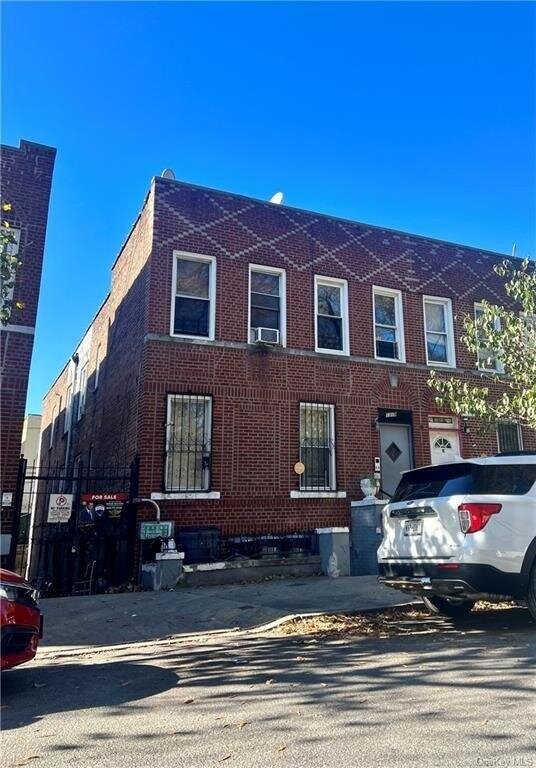
Description: 1319 Harrod Ave, Bronx, NY 10472 is a Multi Family Home built in 1928. This property was last sold for $670,000 in 2018 and currently has an estimated value of $1,011,300. According to the Bronx public records, the property at 1319 Harrod Ave, Bronx, NY 10472 has approximately 3,240 square feet, with a lot size of 2,500 square feet. Nearby schools include Ps 196, Ps 195 and Ps 214.
3,240 sqft
2,500 lot size
6 beds
4 baths
Year Built: 1928
Pre-foreclosure
1319 Harrod Ave, Bronx, NY 10472
Last Updated: December 19, 2023
1
Multi Family Home
Estimated Market Value EMV $ 1,011,300
1319 Harrod Ave
bool(false)

bool(true)

bool(true)

int(0)
Estimated Market Value EMV $ 1,011,300
Foreclosure History
for 1319 Harrod Ave
for 1319 Harrod Ave
1319 Harrod Ave, Bronx, NY 10472 is a Multi Family Home built in 1928. This property was last sold for $670,000 in 2018 and currently has an estimated value of $1,011,300. According to the Bronx public records, the property at 1319 Harrod Ave, Bronx, NY 10472 has approximately 3,240 square feet, with a lot size of 2,500 square feet. Nearby schools include Ps 196, Ps 195 and Ps 214.
Property features
Community Features:
Community Features:
Park
Park
Parking Features:
Parking Features:
Public Parking
Public Parking
Tenant Pays:
Tenant Pays:
Gas, Heat
Gas, Heat
Full Bathrooms:
Full Bathrooms:
4
4
Total Bathrooms:
Total Bathrooms:
4
4
Cooling Features:
Cooling Features:
Window Unit(s)
Window Unit(s)
Heating Features:
Heating Features:
Oil, Hot Water
Oil, Hot Water
Association:
Association:
No
No
Calculated Total Monthly Association Fees:
Calculated Total Monthly Association Fees:
0
0
Basement Description:
Basement Description:
Finished
Finished
Basement Features:
Basement Features:
Finished
Finished
Sewer:
Sewer:
Public Sewer
Public Sewer
Water Source:
Water Source:
Public
Public
Lot Description:
Lot Description:
Near Public Transit
Near Public Transit
Lot Size Acres:
Lot Size Acres:
0.0573921
0.0573921
Lot Size Square Feet:
Lot Size Square Feet:
2500
2500
Number of 1 Bedroom Units:
Number of 1 Bedroom Units:
2
2
Number of 2 Bedroom Units:
Number of 2 Bedroom Units:
2
2
Number of Units:
Number of Units:
4
4
Elementary School District:
Elementary School District:
Bronx 12
Bronx 12
High School District:
High School District:
Bronx 12
Bronx 12
Middle or Junior School District:
Middle or Junior School District:
Bronx 12
Bronx 12
Common Walls:
Common Walls:
2+ Common Walls
2+ Common Walls
Construction Materials:
Construction Materials:
Brick
Brick
Property Age:
Property Age:
95
95
Property Attached:
Property Attached:
Yes
Yes
Total Square Feet Living:
Total Square Feet Living:
3240
3240
Year Built Source:
Year Built Source:
Owner
Owner
Year Built:
Year Built:
1928
1928
Annual Tax Amount:
Annual Tax Amount:
14098.00
14098.00
County:
County:
Bronx
Bronx
List Price Low:
List Price Low:
1299000
1299000
Number of Separate Electric Meters:
Number of Separate Electric Meters:
5
5
Number of Separate Gas Meters:
Number of Separate Gas Meters:
4
4
Parcel Number:
Parcel Number:
03868-0059
03868-0059
Property Subtype:
Property Subtype:
Multi Family
Multi Family
Source Listing Status:
Source Listing Status:
Expired
Expired
Source Property Type:
Source Property Type:
Residential Income
Residential Income
Source System Name:
Source System Name:
C2C
C2C
Building Class:
C3
Walk Up Apartments: Four Families
Floors on Main Building:
2
Building Dimensions:
20'
Actual Square Footage:
3,240
Calculated Square Footage:
3,240
Residential Floor Area:
3,240
Address:
1319 HARROD AVENUE
BIN
Name 1319 HARROD AVENUE
Land Use:
02
Multi-Family Walk-Up Buildings
Calculated Lot Perimeter:
249.90 ft
Zoning Districts:
R6
Moderate-density residence district
Max Residential FAR:
2.43
Max Residential Sqft:
6,075
Buildable Residential Sqft:
2,835
Residential Area Distribution:
Assessed Land Value:
$142,200
Assessed Total Value:
$288,000
Last Recording Date:
Jan 8, 2024
Property Assessment Data:
Tax Class:
2A
4-6 unit rental building
Taxable Assessed Value:
$134,304
Estimated Market Value by NYC DOF :
$640,000
Community District (CD):
209
City Council District:
17
Document DateDocument Type Unit Amount
Date
Event
Price
Price/Sqft
Source
Dec 19, 2023
Listing removed
$1,299,000
$401
OneKeyMLS
May 18, 2018
Sold
$670,000
$207
Public Record
Apr 10, 2007
Sold
$514,100
$159
Public Record
Feb 1, 1982
Sold
$47,000
$15
Public Record
Year
Taxes
Land
Additions
Total Assessment
2022
$14,098
$142,200
$143,550
$285,750
2021
$13,088
$142,200
$86,400
$228,600
2020
$13,307
$142,200
$108,900
$251,100
2019
$13,029
$142,200
$119,250
$261,450
2018
$12,068
$60,472
$35,211
$95,683
2017
$11,273
$59,341
$29,295
$88,636
2016
$10,580
$60,597
$21,477
$82,074
2015
$10,215
$63,737
$15,733
$79,470
2015
$10,572
$69,157
$12,912
$82,069
2014
$9,675
$70,910
$2,693
$73,603
2011
$8,480
$59,911
$3,223
$63,134
2010
$8,429
$59,911
$3,223
$63,134
2009
$8,094
$34,694
$28,436
$63,130
2007
$6,256
$15,759
$36,689
$52,448
Address
Price
Built
Beds
Baths
Sqft
Lot Size
Distance
1222 Simpson St
Bronx, NY 10459MF
$999,999
01/11/2024
1920
9
5
2,730
-510difference
2,500
0.96 mi
1951 Benedict Ave
Bronx, NY 10462MF
$1,100,000
04/04/2024
1925
5
4
1,890
-1,350
5,001
0.84 mi
1146 Thieriot Ave
Bronx, NY 10472MF
$600,000
12/12/2023
1925
4
3
1,656
-1,584
2,500
0.62 mi
Address
Price
Built
Beds
Baths
Sqft
Lot Size
Distance
588 E 170th St
Bronx, NY 10456MF
$995,000
29 days ago
2002
6
4
3,234
-6difference
3,535
1.40 mi
1273 Havemeyer Ave
Bronx, NY 10462MF
$1,395,000
60 days ago
—
7
4
3,280
+40
3,219
1.36 mi
992 Jennings St
Bronx, NY 10460MF
$1,150,000
131 days ago
2003
7
5
3,300
+60
1,498
0.69 mi
1857 Holland Ave
Bronx, NY 10462MF
$915,000
234 days ago
1915
6
5
3,096
-144
2,500
1.12 mi
298-300 Zerega Ave
Bronx, NY 10473MF
$975,000
47 days ago
2011
5
3
3,068
-172
2,082
1.99 mi
1335 Clay Ave
Bronx, NY 10456MF
$999,000
25 days ago
2007
7
3
3,060
-180
1,616
1.81 mi
904 Bryant Ave
Bronx, NY 10474MF
$900,000
63 days ago
1899
5
3
3,425
+185
1,999
1.06 mi
608 Commonwealth Ave
Bronx, NY 10473MF
$949,900
104 days ago
1955
6
3
3,050
-190
3,905
1.20 mi
705 E 183rd St
Bronx, NY 10458MF
$869,999
209 days ago
2000
6
3
3,450
+210
1,725
1.46 mi
945 E 181st St
Bronx, NY 10460MF
$925,000
235 days ago
1997
6
3
3,013
-227
2,321
0.91 mi
Estimated values are not a substitute for professional expertise. Contact your RE agent for a market assessment.
School Name
Rating
Grades
Parent Rating
Distance
Ps 196
, The Bronx , NY 10472
3 / 10
K−5
0.19 mi
St. Thomas Aquinas Elementary School
, The Bronx , NY 10460
—
PK−8
0.78 mi
Blessed Sacrament School
, Bronx , NY 10472
—
K−8
0.53 mi
St Anthony School
, Bronx , NY 10460
—
K−8
0.48 mi
Metropolitan Soundview High (The)
, The Bronx , NY 10472
2 / 10
9−12
0.20 mi
Mott Hall V
, The Bronx , NY 10472
6 / 10
6−12
0.15 mi
Ps 195
, The Bronx , NY 10472
3 / 10
K−5
0.19 mi
The Cinema School
, The Bronx , NY 10472
4 / 10
9−12
0.15 mi
School Of Performing Arts
, The Bronx , NY 10459
4 / 10
6−8
—
1.26 mi
Ps 214
, The Bronx , NY 10460
4 / 10
K−8
0.54 mi
FEMA Zone (Est.)
X (unshaded)
Flood insurance:
Recommended
Flood risks are increasing as sea levels rise and weather patterns change.
This property has a
Major Flood Factor
.
Please Log In
Please wait... If this message is not eventually replaced by the proper contents of the document, your PDF viewer may not be able to display this type of document.
You can upgrade to the latest version of Adobe Reader for Windows®, Mac, or Linux® by visiting
https://get.adobe.com/reader/ this link .
For more assistance with Adobe Reader visit
http://get.adobe.com/reader/ this link .
You can download this PDF-document from
here .