14-28 Parsons Blvd, Whitestone, NY 11357 Queens County Last Updated: October 23, 2023
Foreclosure: Estimated Market Value $1,632,200
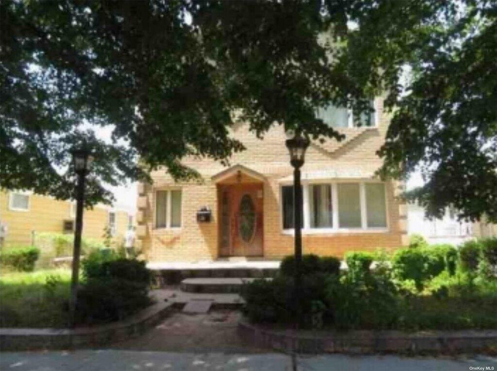
Description: 14-28 Parsons Blvd, Whitestone, NY 11357 is a Single Family Home built in 1950. This property was last sold for $250,000 in 1999 and currently has an estimated value of $1,632,200. According to the Whitestone public records, the property at 14-28 Parsons Blvd, Whitestone, NY 11357 has approximately 3,096 square feet, with a lot size of 4,550 square feet. Nearby schools include Ps 21 Edward Hart, Ps 193 Alfred J Kennedy and Ps 79 Francis Lewis.
3,096 sqft
4,550 lot size
4 beds
3 baths
Year Built: 1950
Foreclosure
14-28 Parsons Blvd, Whitestone, NY 11357
Last Updated: October 23, 2023
1
Single Family Home
Town House
Estimated Market Value EMV $ 1,632,200
14-28 Parsons Blvd
bool(false)

bool(true)

bool(true)

int(0)
Estimated Market Value EMV $ 1,632,200
for 14-28 Parsons Blvd
Estimated Reasonable Offer
$ 1,387,300
Type
Single Family Home
Town House
14-28 Parsons Blvd, Whitestone, NY 11357 is a Single Family Home built in 1950. This property was last sold for $250,000 in 1999 and currently has an estimated value of $1,632,200. According to the Whitestone public records, the property at 14-28 Parsons Blvd, Whitestone, NY 11357 has approximately 3,096 square feet, with a lot size of 4,550 square feet. Nearby schools include Ps 21 Edward Hart, Ps 193 Alfred J Kennedy and Ps 79 Francis Lewis.
Property facts
Property features
Heating Features:
Heating Features:
Oil, Hot Water
Oil, Hot Water
Full Bathrooms:
Full Bathrooms:
3
3
Total Bathrooms:
Total Bathrooms:
3
3
Association:
Association:
No
No
Calculated Total Monthly Association Fees:
Calculated Total Monthly Association Fees:
0
0
Sewer:
Sewer:
Public Sewer
Public Sewer
Water Source:
Water Source:
Public
Public
Attached Garage:
Attached Garage:
Yes
Yes
Garage Spaces:
Garage Spaces:
1
1
Parking Features:
Parking Features:
Private, Attached, 1 Car Attached
Private, Attached, 1 Car Attached
Lot Size Acres:
Lot Size Acres:
0.1044536
0.1044536
Lot Size Dimensions:
Lot Size Dimensions:
39x116.67
39x116.67
Lot Size Square Feet:
Lot Size Square Feet:
4550
4550
Basement Description:
Basement Description:
Partially Finished
Partially Finished
Basement Features:
Basement Features:
Partially Finished
Partially Finished
Total Rooms:
Total Rooms:
7
7
Architectural Style:
Architectural Style:
Colonial
Colonial
Common Walls:
Common Walls:
No Common Walls
No Common Walls
Construction Materials:
Construction Materials:
Brick
Brick
Property Age:
Property Age:
73
73
Year Built:
Year Built:
1950
1950
Elementary School District:
Elementary School District:
Queens 25
Queens 25
High School District:
High School District:
Queens 25
Queens 25
High School:
High School:
Francis Lewis High School
Francis Lewis High School
Middle School:
Middle School:
Flushing High School
Flushing High School
Middle or Junior School District:
Middle or Junior School District:
Queens 25
Queens 25
Annual Tax Amount:
Annual Tax Amount:
11118.00
11118.00
County:
County:
Queens
Queens
Cross Street:
Cross Street:
14th Ave
14th Ave
Directions:
Directions:
Google Maps
Google Maps
List Price Low:
List Price Low:
1100000
1100000
Parcel Number:
Parcel Number:
04114-0020
04114-0020
Property Subtype:
Property Subtype:
Single Family Residence
Single Family Residence
Source Listing Status:
Source Listing Status:
Withdrawn
Withdrawn
Source Property Type:
Source Property Type:
Residential
Residential
Source System Name:
Source System Name:
C2C
C2C
Tax Block:
Tax Block:
4114
4114
Township:
Township:
Queens
Queens
Building Class:
A1
One Family Dwellings: Two Stories Detached (Small Or Moderate Size, With Or Without Attic)
Floors on Main Building:
2
Building Dimensions:
24'
Actual Square Footage:
3,096
Calculated Square Footage:
2,088
Residential Floor Area:
2,064
Basement:
Above grade full basement
Address:
14-28 PARSONS BOULEVARD
BIN
Name 1428 GARAGE PARSONS BOULEVARD 14-28 PARSONS BOULEVARD
Land Use:
01
One & Two Family Buildings
Lot Dimensions:
39'
Calculated Lot Perimeter:
303.05 ft
Zoning Districts:
R2A
Lower-density residence district
Max Residential FAR:
0.50
Max Residential Sqft:
2,275
Buildable Residential Sqft:
0
Residential Area Distribution:
Assessed Land Value:
$14,520
Assessed Total Value:
$88,680
Last Recording Date:
Jan 8, 2024
Property Assessment Data:
Tax Class:
1
One- to three-unit residential properties
Taxable Assessed Value:
$56,982
Estimated Market Value by NYC DOF :
$1,478,000
Community District (CD):
407
City Council District:
19
Document DateDocument Type Unit Amount
Date
Event
Price
Price/Sqft
Source
Aug 25, 2023
Listing removed
$1,100,000
—
OneKeyMLS
Aug 25, 2023
Listing removed
$1,100,000
—
OneKeyMLS
Aug 24, 2023
Listed
$1,100,000
—
OneKeyMLS
Aug 24, 2023
Listed
$1,100,000
—
OneKeyMLS
Feb 13, 2021
Listing removed
$650,000
—
MyStateMLS
Apr 1, 1999
Sold
$250,000
$81
Public Record
Mar 13, 1998
Sold
$160,000
$52
Public Record
Year
Taxes
Land
Additions
Total Assessment
2022
$10,381
$14,520
$69,180
$83,700
2021
$10,944
$14,520
$75,000
$89,520
2020
$10,654
$14,520
$65,880
$80,400
2019
$9,933
$14,520
$65,940
$80,460
2018
$9,544
$11,684
$33,940
$45,624
2017
$8,834
$11,462
$31,876
$43,338
2016
$8,664
$11,301
$32,037
$43,338
2015
$8,202
$15,247
$26,697
$41,944
2014
$7,581
$14,136
$25,435
$39,571
2013
$7,296
$13,618
$24,402
$38,020
2011
$6,271
$20,243
$15,872
$36,115
2010
$5,972
$21,427
$14,688
$36,115
2009
$5,634
$23,598
$11,356
$34,954
2007
$4,645
$5,573
$24,523
$30,096
Address
Price
Built
Beds
Baths
Sqft
Lot Size
Distance
2-40 149th Pl
Whitestone, NY 11357SF
$1,860,000
04/02/2024
1999
4
3
3,100
+4difference
4,928
0.87 mi
20-35 157th St
Flushing, NY 11357SF
$990,000
11/29/2023
1970
4
3
3,306
+210
2,691
0.97 mi
1307 157th St
Whitestone, NY 11357SF
$1,600,000
04/04/2024
1955
4
3
2,880
-216
5,196
0.97 mi
3-19 147 Pl
Whitestone, NY 11357SF
$1,650,000
11/22/2023
2007
4
4
2,600
-496
4,460
0.70 mi
145-38 3rd Ave
Whitestone, NY 11357SF
$2,730,000
01/18/2024
1950
4
6
3,600
+504
7,500
0.67 mi
1355 145th Pl
Whitestone, NY 11357SF
$1,300,000
12/22/2023
1970
3
3
2,137
-959
4,600
0.11 mi
15-20 147th St
Whitestone, NY 11357SF
$1,115,000
04/29/2024
1935
4
2
1,580
-1,516
2,950
0.19 mi
13-31 142 St
Malba, NY 11357SF
$950,000
11/28/2023
1955
3
2
1,222
-1,874
3,990
0.26 mi
147-30 16th Rd
Whitestone, NY 11357SF
$960,000
12/08/2023
1930
3
3
1,282
-1,814
3,000
0.27 mi
147-17 17 Rd
Whitestone, NY 11357SF
$910,000
12/11/2023
1930
3
2
1,440
-1,656
3,325
0.27 mi
Address
Price
Built
Beds
Baths
Sqft
Lot Size
Distance
156-09 33rd Ave
Flushing, NY 11354SF
$1,399,000
2 days ago
1925
5
4
3,118
+22difference
5,000
1.42 mi
162-03 14 Ave
Whitestone, NY 11357SF
$2,688,800
8 days ago
2004
4
5
3,000
-96
7,480
1.19 mi
32-26 162nd St
Flushing, NY 11358SF
$1,829,000
29 days ago
1901
5
5
3,200
+104
6,900
1.57 mi
154-46 22nd Ave
Whitestone, NY 11357SF
$1,719,000
31 days ago
1960
4
3
3,201
+105
6,399
0.96 mi
14-12 156th St
Beechhurst, NY 11357SF
$1,599,898
51 days ago
1986
5
4
2,970
-126
4,000
0.87 mi
12-14 Utopia Pkwy
Whitestone, NY 11357SF
$1,599,000
30 days ago
—
3
3
2,926
-170
4,602
1.48 mi
141-33 11th Ave
Malba, NY 11357SF
$1,749,000
89 days ago
2007
3
5
2,881
-215
4,200
0.35 mi
Estimated values are not a substitute for professional expertise. Contact your RE agent for a market assessment.
School Name
Rating
Grades
Parent Rating
Distance
Whitestone School
, Whitestone , NY 11357
—
—
0.07 mi
College Point Collaborative
, Queens , NY 11356
3 / 10
6−8
1.11 mi
Qsac School
, Queens , NY 11357
—
—
0.50 mi
Jhs 194 William Carr
, Queens , NY 11357
7 / 10
6−8
0.84 mi
Ps 21 Edward Hart
, Queens , NY 11354
7 / 10
K−5
0.84 mi
Ps 193 Alfred J Kennedy
, Queens , NY 11357
10 / 10
K−5
0.79 mi
Holy Trinity School
, Queens , NY 11357
—
PK−8
0.16 mi
Jhs 185 Edward Bleeker
, Queens , NY 11354
9 / 10
6−8
0.79 mi
Ps 79 Francis Lewis
, Queens , NY 11357
9 / 10
K−5
0.24 mi
Queens High For Language Studies
, Queens , NY 11354
5 / 10
9−12
1.46 mi
FEMA Zone (Est.)
X (unshaded)
Flood insurance:
Recommended
Flood risks are increasing as sea levels rise and weather patterns change.
This property has a
Minimal Flood Factor
.
Please Log In
Please wait... If this message is not eventually replaced by the proper contents of the document, your PDF viewer may not be able to display this type of document.
You can upgrade to the latest version of Adobe Reader for Windows®, Mac, or Linux® by visiting
https://get.adobe.com/reader/ this link .
For more assistance with Adobe Reader visit
http://get.adobe.com/reader/ this link .
You can download this PDF-document from
here .