15 Hampton Pl, Freeport, NY 11520 Nassau County Last Updated: February 26, 2024
Foreclosure: Estimated Market Value $1,021,000
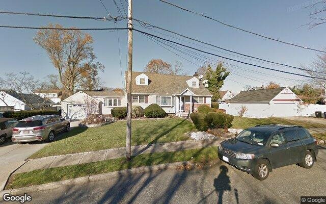
Description: 15 Hampton Pl, Freeport, NY 11520 is a Single Family Home built in 1949. This property was last sold for $230,000 in 1988 and currently has an estimated value of $1,021,000. According to the Freeport public records, the property at 15 Hampton Pl, Freeport, NY 11520 has approximately 1,840 square feet, with a lot size of 12,301 square feet. Nearby schools include Leo F Giblyn School, Columbus Avenue School and Caroline G Atkinson School.
1,840 sqft
12,301 lot size
4 beds
1 baths
Year Built: 1949
Foreclosure
15 Hampton Pl, Freeport, NY 11520
Last Updated: February 26, 2024
1
Single Family Home
Town House
Estimated Market Value EMV $ 1,021,000
15 Hampton Pl
bool(false)

bool(true)

bool(true)

int(0)
Estimated Market Value EMV $ 1,021,000
for 15 Hampton Pl
Estimated Reasonable Offer
$ 827,000
Type
Single Family Home
Town House
15 Hampton Pl, Freeport, NY 11520 is a Single Family Home built in 1949. This property was last sold for $230,000 in 1988 and currently has an estimated value of $1,021,000. According to the Freeport public records, the property at 15 Hampton Pl, Freeport, NY 11520 has approximately 1,840 square feet, with a lot size of 12,301 square feet. Nearby schools include Leo F Giblyn School, Columbus Avenue School and Caroline G Atkinson School.
Property facts
Property features
Fireplace features:
Fireplace features:
Yes
Yes
Year Built:
Year Built:
1949
1949
Living Area:
Living Area:
1840
1840
Cooling features:
Cooling features:
Central
Central
Heating features:
Heating features:
Central
Central
Total bath(s):
Total bath(s):
1
1
Total full bath(s):
Total full bath(s):
1
1
Total rooms:
Total rooms:
4
4
Date
Event
Price
Price/Sqft
Source
Feb 7, 2024
Sold
$535,000
$291
Public Record
Sep 21, 1988
Sold
$230,000
$125
Public Record
Year
Taxes
Land
Additions
Total Assessment
2022
$7,956
$236
$204
$440
2021
$11,547
$236
$204
$440
2020
$7,818
$226
$195
$421
2019
$7,049
$502
$68
$570
2018
$6,817
$502
$68
$570
2016
$6,154
$502
$201
$703
2016
$6,315
$502
$68
$570
2016
$6,315
$502
$68
$570
2015
$6,180
$502
$287
$789
2014
$7,023
$552
$316
$868
2013
$7,361
$552
$362
$914
2011
$7,033
$552
$362
$914
2010
$7,395
$552
$662
$1,214
2010
$7,395
$552
$435
$987
2009
$7,071
$552
$617
$1,169
2007
$6,943
$552
$551
$1,103
Address
Price
Built
Beds
Baths
Sqft
Lot Size
Distance
213 Porterfield Pl
Freeport, NY 11520SF
$680,000
02/16/2024
1949
3
2
1,986
+146difference
8,500
0.98 mi
926 Phyllis Dr
Baldwin, NY 11510SF
$708,000
11/21/2023
1964
4
3
2,022
+182
7,777
0.96 mi
358 Saint Marks Ave
Freeport, NY 11520SF
$505,000
03/27/2024
1964
3
2
1,608
-232
4,984
0.42 mi
157 Gordon Pl
Freeport, NY 11520SF
$515,000
04/23/2024
1930
3
2
1,606
-234
8,000
0.88 mi
906 Hastings St
Baldwin, NY 11510SF
$480,000
01/23/2024
1954
3
2
1,605
-235
7,000
0.71 mi
38 Hampton Pl
Freeport, NY 11520SF
$630,000
01/11/2024
1928
3
2
1,387
-453
6,500
0.06 mi
189 Saint Marks Ave
Freeport, NY 11520SF
$510,000
12/13/2023
1912
4
1
1,398
-442
5,000
0.19 mi
50 Lester Ave
Freeport, NY 11520SF
$510,000
01/16/2024
1935
4
2
1,386
-454
4,800
0.27 mi
1110 Steele Blvd
Baldwin, NY 11510SF
$755,000
04/17/2024
1959
6
2
2,300
+460
8,000
0.35 mi
598 S Long Beach Ave
Freeport, NY 11520SF
$599,000
12/19/2023
1920
3
2
2,079
+239
8,800
0.39 mi
Address
Price
Built
Beds
Baths
Sqft
Lot Size
Distance
479 Roosevelt Ave
Freeport, NY 11520SF
$589,900
48 days ago
1956
3
3
1,854
+14difference
7,000
0.41 mi
696 Jeffrey Dr
Baldwin, NY 11510SF
$598,000
464 days ago
1959
3
3
1,824
-16
6,000
1.15 mi
72 Shonnard Ave
Freeport, NY 11520SF
$560,000
93 days ago
1971
4
2
1,808
-32
5,000
1.81 mi
1000 Woodoak Dr
Baldwin, NY 11510SF
$799,000
23 days ago
1959
4
3
1,800
-40
6,710
0.74 mi
665 Koelbel Ct
Baldwin, NY 11510SF
$675,000
38 days ago
1926
3
2
1,880
+40
6,750
1.17 mi
2583 Park Ave
Baldwin, NY 11510SF
$649,000
21 days ago
1923
3
2
1,766
-74
8,250
1.03 mi
48 W 3rd St
Freeport, NY 11520SF
$749,000
188 days ago
1940
4
3
1,918
+78
10,000
0.98 mi
9 King St
Oceanside, NY 11572SF
$729,000
98 days ago
1951
4
2
1,926
+86
6,240
1.92 mi
2719 Fox Rd
Baldwin, NY 11510SF
$749,000
48 days ago
1953
3
1
1,935
+95
9,425
0.51 mi
2017 Pine St
North Baldwin, NY 11510SF
$689,000
108 days ago
1925
4
2
1,719
-121
6,250
1.86 mi
Estimated values are not a substitute for professional expertise. Contact your RE agent for a market assessment.
School Name
Rating
Grades
Parent Rating
Distance
Leo F Giblyn School
, Freeport , NY 11520
8 / 10
K−4
0.52 mi
Hi Hello Child Care Center 2
, Freeport , NY 11520
—
—
—
0.85 mi
John W Dodd Middle School
, Freeport , NY 11520
4 / 10
7−8
1.23 mi
Woodward Mental Health Center
, Freeport , NY 11520
—
6−12
—
0.96 mi
Columbus Avenue School
, Freeport , NY 11520
—
K−K
1.89 mi
Freeport High School
, Freeport , NY 11520
4 / 10
9−12
1.15 mi
Children's World Montessori School
, Freeport , NY 11520
—
PK−1
—
0.96 mi
Caroline G Atkinson School
, Freeport , NY 11520
3 / 10
5−6
1.85 mi
FEMA Zone (Est.)
X (unshaded)
Flood insurance:
Recommended
Flood risks are increasing as sea levels rise and weather patterns change.
This property has a
Severe Flood Factor
.
Please Log In
Please wait... If this message is not eventually replaced by the proper contents of the document, your PDF viewer may not be able to display this type of document.
You can upgrade to the latest version of Adobe Reader for Windows®, Mac, or Linux® by visiting
https://get.adobe.com/reader/ this link .
For more assistance with Adobe Reader visit
http://get.adobe.com/reader/ this link .
You can download this PDF-document from
here .