")

bool(false)

bool(true)

bool(true)

int(0)
Staten Island, NY 10314
Foreclosure History
Property details
The description and property data below may have been provided by a third party, the homeowner or public records.
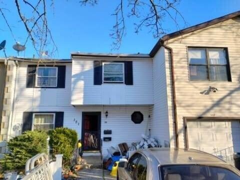
151 Regis Dr, Staten Island, NY 10314 is a Single Family Home built in 1975. This property currently has an estimated value of $716,800. According to the Staten Island public records, the property at 151 Regis Dr, Staten Island, NY 10314 has approximately 1,439 square feet, with a lot size of 2,750 square feet. Nearby schools include Ps 22 Graniteville, Ps 60 Alice Austen, John W Lavelle Preparatory Charter School and Staten Island School Of Civic Leadership.
Primary Land Use and Tax Lot Information
for 151 Regis Dr

Property Price History
for 151 Regis Dr
| Date | Event | Price | ||
|---|---|---|---|---|
| Oct 16, 2023 | Listing removed | $199,000 | $138 | MyStateMLS |
| Nov 5, 2022 | Listed | $199,000 | $138 | MyStateMLS |
Property Tax History
for 151 Regis Dr
| Year | Taxes | |
|---|---|---|
| 2023 | $4,193 | $30,300 |
| 2022 | $4,122 | $28,440 |
Sold Homes
near 151 Regis Dr
| Address | Price | Beds | Baths |
|---|---|---|---|
|
Staten Island, NY 10303SF
|
$618,000
04/07/2025
|
3
|
3
|
|
Staten Island, NY 10303SF
|
$500,000
02/06/2025
|
3
|
2
|
|
Staten Island, NY 10302SF
|
$765,000
03/07/2025
|
3
|
2
|
|
Staten Island, NY 10314SF
|
$605,000
05/27/2025
|
3
|
2
|
|
Staten Island, NY 10303SF
|
$650,000
02/03/2025
|
3
|
3
|
Homes For Sale
near 151 Regis Dr
| Address | Price | Beds | Baths |
|---|---|---|---|
|
Staten Island, NY 10314SF
|
$849,900
274 days ago
|
3
|
2
|
|
Staten Island, NY 10303SF
|
$650,000
220 days ago
|
3
|
2
|
|
Staten Island, NY 10303SF
|
$669,000
121 days ago
|
3
|
2
|
|
Staten Island, NY 10314SF
|
$829,999
232 days ago
|
3
|
4
|
|
Staten Island, NY 10303SF
|
$425,000
268 days ago
|
3
|
2
|
Home Value
for 151 Regis Dr
Estimated values are not a substitute for professional expertise. Contact your RE agent for a market assessment.
Schools
serving 151 Regis Dr
| School Name | Rating |
|---|---|
|
400 Caswell Avenue, Staten Island, NY 10314
|
— |
|
33 Ferndale Avenue, Staten Island, NY 10314
|
7 / 10 |
|
1860 Forest Avenue, Staten Island, NY 10303
|
5 / 10 |
Data provided by
GreatSchools.org © 2025. All Rights Reserved.
School service boundaries are intended to be used as reference only.
To verify enrollment eligibility for a property, contact the school directly.
Flood Factor
for 151 Regis Dr
3
|10
Moderate

FEMA Zone (Est.)
X (unshaded)
Flood insurance:
Recommended
Flood risks are increasing as sea levels rise and weather patterns change.
This property has a
Moderate Flood Factor
.
Flood Factor data provided by FloodFactor.