1726 E 22nd St, Brooklyn, NY 11229 Kings County Last Updated: March 13, 2024
Pre-Foreclosure: Lis Pendens, Estimated Market Value $2,158,000
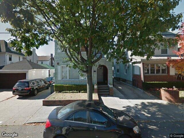
Description: 1726 E 22nd St, Brooklyn, NY 11229 is a Multi Family Home built in 1930. This property was last sold for $225,000 in 1991 and currently has an estimated value of $2,158,000. According to the Brooklyn public records, the property at 1726 E 22nd St, Brooklyn, NY 11229 has approximately 4,080 square feet, with a lot size of 4,000 square feet. Nearby schools include Ps 206 Joseph F Lamb, Ps 197 The Kings Highway Academy and Ps 255 Barbara Reing School.
4,080 sqft
4,000 lot size
Year Built: 1930
Pre-foreclosure
1726 E 22nd St, Brooklyn, NY 11229
Last Updated: March 13, 2024
1
Multi Family Home
Estimated Market Value EMV $ 2,158,000
1726 E 22nd St
bool(false)

bool(true)

bool(true)

int(0)
Estimated Market Value EMV $ 2,158,000
Foreclosure History
for 1726 E 22nd St
for 1726 E 22nd St
1726 E 22nd St, Brooklyn, NY 11229 is a Multi Family Home built in 1930. This property was last sold for $225,000 in 1991 and currently has an estimated value of $2,158,000. According to the Brooklyn public records, the property at 1726 E 22nd St, Brooklyn, NY 11229 has approximately 4,080 square feet, with a lot size of 4,000 square feet. Nearby schools include Ps 206 Joseph F Lamb, Ps 197 The Kings Highway Academy and Ps 255 Barbara Reing School.
Property features
Year Built:
Year Built:
1930
1930
Zoning:
Zoning:
R3-2
R3-2
Living Area:
Living Area:
4080
4080
Building Class:
B2
Two Family Dwellings: Frame
Floors on Main Building:
2.5
Building Dimensions:
24'
Actual Square Footage:
4,080
Calculated Square Footage:
3,420
Residential Floor Area:
4,080
Extension:
Extension and garage
Basement:
Below grade full basement
Address:
1726 EAST 22 STREET
BIN
Name 1726 GARAGE EAST 22 STREET 1726 EAST 22 STREET
Land Use:
01
One & Two Family Buildings
Calculated Lot Perimeter:
278.41 ft
Zoning Districts:
R3-2
Lower-density residence district
Max Residential FAR:
0.50
Max Residential Sqft:
2,000
Buildable Residential Sqft:
0
Residential Area Distribution:
Assessed Land Value:
$22,260
Assessed Total Value:
$162,000
Exempt Total Value:
$1,400
Last Recording Date:
Jan 8, 2024
Property Assessment Data:
Tax Class:
1
One- to three-unit residential properties
Taxable Assessed Value:
$55,498
Estimated Market Value by NYC DOF :
$2,700,000
Community District (CD):
315
City Council District:
48
Document DateDocument Type Unit Amount
Date
Event
Price
Price/Sqft
Source
Oct 1, 1991
Sold
$225,000
$55
Public Record
Year
Taxes
Land
Additions
Total Assessment
2022
$10,923
$22,260
$158,640
$180,900
2021
$10,869
$22,260
$117,420
$139,680
2020
$10,298
$22,260
$94,500
$116,760
2019
$9,625
$22,260
$70,560
$92,820
2018
$9,553
$10,887
$36,240
$47,127
2017
$9,239
$11,957
$34,839
$46,796
2016
$8,528
$13,357
$30,855
$44,212
2015
$7,846
$14,040
$27,670
$41,710
2014
$7,265
$11,305
$28,208
$39,513
2013
$7,237
$13,484
$25,789
$39,273
2012
$6,806
$19,042
$19,955
$38,997
2010
$5,662
$20,538
$16,306
$36,844
2009
$5,390
$19,087
$15,672
$34,759
2007
$4,861
$7,848
$23,650
$31,498
Address
Price
Built
Beds
Baths
Sqft
Lot Size
Distance
1241 E 18th St
Brooklyn, NY 11230MF
$1,650,000
01/31/2024
1925
—
5
3,432
-648difference
3,000
0.80 mi
1504 E 34th St
Brooklyn, NY 11234MF
$875,000
01/23/2024
1930
—
3
3,234
-846
2,000
0.80 mi
1561 E 31st St
Brooklyn, NY 11234MF
$1,355,000
03/27/2024
1930
5
3
2,576
-1,504
2,600
0.59 mi
1546 E 19th St
Brooklyn, NY 11230MF
$1,180,000
11/16/2023
1975
—
5
2,500
-1,580
2,000
0.28 mi
1439 E 13th St
Brooklyn, NY 11230MF
$1,120,000
01/16/2024
—
6
3
2,480
-1,600
2,000
0.60 mi
1661 Burnett St
Brooklyn, NY 11229MF
$838,000
01/23/2024
1945
4
3
1,863
-2,217
1,476
0.48 mi
1583 E 12th St
Brooklyn, NY 11230MF
$920,000
01/18/2024
—
—
2
2,163
-1,917
2,025
0.51 mi
2105 E 21st St
Brooklyn, NY 11229MF
$1,700,000
03/26/2024
1925
6
2
2,260
-1,820
4,000
0.57 mi
1838 Brown St
Brooklyn, NY 11229MF
$880,000
04/22/2024
1920
5
3
1,890
-2,190
1,800
0.57 mi
1853 Stuart St
Brooklyn, NY 11229MF
$910,000
02/28/2024
1925
4
3
1,890
-2,190
1,800
0.61 mi
Address
Price
Built
Beds
Baths
Sqft
Lot Size
Distance
1709 W 5th St
Brooklyn, NY 11223MF
$1,750,000
43 days ago
1920
—
4
4,080
2,567
1.41 mi
1302 Foster Ave
Brooklyn, NY 11230MF
$1,850,000
115 days ago
1910
6
4
4,100
+20difference
—
1.78 mi
2196 McDonald Ave
Brooklyn, NY 11223MF
$1,800,000
714 days ago
1920
14
5
4,140
+60
3,375
1.36 mi
1842 Schenectady Ave
Brooklyn, NY 11234MF
$1,100,000
294 days ago
1960
7
5
4,009
-71
3,750
1.64 mi
1823 Avenue O
Brooklyn, NY 11230MF
$1,879,000
154 days ago
1925
7
6
4,000
-80
2,400
0.35 mi
4676 Bedford Ave
Brooklyn, NY 11235MF
$2,389,000
138 days ago
1920
—
9
3,909
-171
3,800
1.56 mi
2027 71st St
Brooklyn, NY 11204MF
$1,850,000
57 days ago
—
6
3
4,290
+210
2,750
1.95 mi
2017 Homecrest Ave
Brooklyn, NY 11229MF
$1,388,888
303 days ago
1925
6
6
4,320
+240
2,000
0.75 mi
2137 Coney Island Ave
Brooklyn, NY 11223MF
$1,399,000
141 days ago
1932
10
4
3,840
-240
2,867
0.60 mi
2413 E 26th St
Brooklyn, NY 11235MF
$1,550,000
308 days ago
1930
—
4
3,800
-280
4,000
1.20 mi
Estimated values are not a substitute for professional expertise. Contact your RE agent for a market assessment.
School Name
Rating
Grades
Parent Rating
Distance
Sarah Dabah School
, Brooklyn , NY 11229
—
K−8
—
0.21 mi
Nefesh Academy
, Brooklyn , NY 11229
—
K−12
0.23 mi
Ps 206 Joseph F Lamb
, Brooklyn , NY 11229
5 / 10
K−8
0.86 mi
Prospect Park Yeshiva
, Brooklyn , NY 11229
—
PK−12
0.32 mi
Ps 197 The Kings Highway Academy
, Brooklyn , NY 11210
7 / 10
K−5
0.22 mi
Jhs 234 Arthur W Cunningham
, Brooklyn , NY 11229
8 / 10
6−8
0.40 mi
Ps 255 Barbara Reing School
, Brooklyn , NY 11229
8 / 10
K−5
0.42 mi
James Madison High School
, Brooklyn , NY 11229
4 / 10
9−12
0.18 mi
Professional Pathways High School
, Brooklyn , NY 11235
1 / 10
9−12
—
1.36 mi
Origins High School
, Brooklyn , NY 11235
4 / 10
9−12
—
1.36 mi
FEMA Zone (Est.)
X (unshaded)
Flood insurance:
Recommended
Flood risks are increasing as sea levels rise and weather patterns change.
This property has a
Minimal Flood Factor
.
Please Log In
Please wait... If this message is not eventually replaced by the proper contents of the document, your PDF viewer may not be able to display this type of document.
You can upgrade to the latest version of Adobe Reader for Windows®, Mac, or Linux® by visiting
https://get.adobe.com/reader/ this link .
For more assistance with Adobe Reader visit
http://get.adobe.com/reader/ this link .
You can download this PDF-document from
here .