1750 Gleason Ave, Bronx, NY 10472 Bronx County Last Updated: April 15, 2024
Pre-Foreclosure: Lis Pendens, Estimated Market Value $979,600
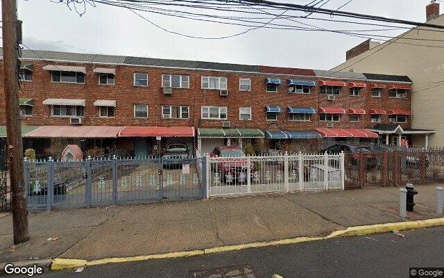
Description: 1750 Gleason Ave, Bronx, NY 10472 is a Multi Family Home built in 1920. This property currently has an estimated value of $979,600. According to the Bronx public records, the property at 1750 Gleason Ave, Bronx, NY 10472 has approximately 2,280 square feet, with a lot size of 2,663 square feet. Nearby schools include Ps 47 John Randolph, Ps 195, Bronx Charter School For Excellence and Ps 214.
2,280 sqft
2,663 lot size
Year Built: 1920
Pre-foreclosure
1750 Gleason Ave, Bronx, NY 10472
Last Updated: April 15, 2024
1
Multi Family Home
Estimated Market Value EMV $ 979,600
1750 Gleason Ave
bool(false)

bool(true)

bool(true)

int(0)
Estimated Market Value EMV $ 979,600
Foreclosure History
for 1750 Gleason Ave
for 1750 Gleason Ave
1750 Gleason Ave, Bronx, NY 10472 is a Multi Family Home built in 1920. This property currently has an estimated value of $979,600. According to the Bronx public records, the property at 1750 Gleason Ave, Bronx, NY 10472 has approximately 2,280 square feet, with a lot size of 2,663 square feet. Nearby schools include Ps 47 John Randolph, Ps 195, Bronx Charter School For Excellence and Ps 214.
Property features
Year Built:
Year Built:
1920
1920
Living Area:
Living Area:
2280
2280
Building Class:
C0
Walk Up Apartments: Three Families
Floors on Main Building:
2
Building Dimensions:
20'
Actual Square Footage:
2,280
Calculated Square Footage:
2,200
Residential Floor Area:
2,280
Basement:
Below grade full basement
Address:
1750 GLEASON AVENUE
BIN
Name 1750 GARAGE GLEASON AVENUE 1750 GLEASON AVENUE
Land Use:
02
Multi-Family Walk-Up Buildings
Lot Dimensions:
25'
Calculated Lot Perimeter:
272.57 ft
Zoning Districts:
R5
Lower-density residence district
Max Residential FAR:
1.25
Max Residential Sqft:
3,329
Buildable Residential Sqft:
1,049
Residential Area Distribution:
Assessed Land Value:
$9,060
Assessed Total Value:
$47,880
Exempt Total Value:
$3,800
Last Recording Date:
Jan 8, 2024
Property Assessment Data:
Tax Class:
1
One- to three-unit residential properties
Taxable Assessed Value:
$34,178
Estimated Market Value by NYC DOF :
$798,000
Community District (CD):
209
City Council District:
18
Document DateDocument Type Unit Amount
Recorded DateDocument Type Unit Amount
Year
Taxes
Land
Additions
Total Assessment
2022
$2,788
$9,060
$34,680
$43,740
2021
$2,771
$9,060
$30,360
$39,420
2020
$2,747
$9,060
$31,920
$40,980
2019
$2,651
$9,060
$26,340
$35,400
2018
$2,464
$6,958
$22,901
$29,859
2017
$2,351
$7,329
$21,453
$28,782
2016
$5,121
$8,747
$18,422
$27,169
2015
$4,935
$10,080
$16,740
$26,820
2015
$4,747
$9,367
$17,007
$26,374
2014
$4,476
$12,732
$12,151
$24,883
2011
$3,805
$13,471
$9,170
$22,641
2010
$3,650
$13,471
$9,170
$22,641
2009
$3,519
$14,902
$7,739
$22,641
2007
$2,821
$3,109
$16,879
$19,988
Address
Price
Built
Beds
Baths
Sqft
Lot Size
Distance
1951 Benedict Ave
Bronx, NY 10462MF
$1,100,000
04/04/2024
1925
5
4
1,890
-390difference
5,001
0.60 mi
1146 Thieriot Ave
Bronx, NY 10472MF
$600,000
12/12/2023
1925
4
3
1,656
-624
2,500
0.24 mi
2126 Blackrock Ave
Bronx, NY 10472MF
$1,150,000
11/30/2023
1927
7
4
3,403
+1,123
3,090
0.83 mi
Address
Price
Built
Beds
Baths
Sqft
Lot Size
Distance
741 E 178th St
Bronx, NY 10457MF
$499,000
88 days ago
1920
5
2
2,280
2,036
1.56 mi
1241 Intervale Ave
Bronx, NY 10459MF
$799,000
153 days ago
1991
—
—
2,280
1,899
1.40 mi
747 Beach Ave
Bronx, NY 10473MF
$849,999
163 days ago
2008
7
4
2,300
+20difference
2,500
0.66 mi
2023 Yates Ave
Bronx, NY 10461MF
$875,000
145 days ago
1955
4
3
2,305
+25
2,701
1.92 mi
1830 Bruckner Blvd
Bronx, NY 10473MF
$850,000
51 days ago
1993
5
3
2,310
+30
2,875
0.39 mi
1032 Rhinelander Ave
Bronx, NY 10461MF
$859,000
58 days ago
1920
7
3
2,250
-30
2,252
1.58 mi
1033 Rev James A Polite Ave
Bronx, NY 10459MF
$625,000
103 days ago
2005
—
—
2,318
+38
1,167
1.66 mi
2282 Beaumont Ave
Bronx, NY 10457MF
$1,225,000
761 days ago
1910
—
—
2,241
-39
1,661
1.78 mi
1055 Virginia Ave
Bronx, NY 10472MF
$1,349,000
129 days ago
1915
8
5
2,328
+48
2,535
0.46 mi
969 E 179th St
Bronx, NY 10460MF
$799,999
142 days ago
1992
5
3
2,205
-75
2,348
1.13 mi
Estimated values are not a substitute for professional expertise. Contact your RE agent for a market assessment.
School Name
Rating
Grades
Parent Rating
Distance
Ps 47 John Randolph
, The Bronx , NY 10472
2 / 10
K−5
0.23 mi
Blessed Sacrament School
, Bronx , NY 10472
—
K−8
0.14 mi
The Cinema School
, The Bronx , NY 10472
4 / 10
9−12
0.52 mi
Mott Hall V
, The Bronx , NY 10472
6 / 10
6−12
0.52 mi
Ps 195
, The Bronx , NY 10472
3 / 10
K−5
0.49 mi
St Anthony School
, Bronx , NY 10460
—
K−8
0.58 mi
Metropolitan Soundview High (The)
, The Bronx , NY 10472
2 / 10
9−12
0.55 mi
Bronx Charter School For Excellence
, The Bronx , NY 10462
8 / 10
K−8
0.59 mi
Islamic Leadership School
, Bronx , NY 10462
—
1−10
—
0.62 mi
Ps 214
, The Bronx , NY 10460
4 / 10
K−8
0.92 mi
FEMA Zone (Est.)
X (shaded)
Flood insurance:
Recommended
Flood risks are increasing as sea levels rise and weather patterns change.
This property has a
Severe Flood Factor
.
Please Log In
Please wait... If this message is not eventually replaced by the proper contents of the document, your PDF viewer may not be able to display this type of document.
You can upgrade to the latest version of Adobe Reader for Windows®, Mac, or Linux® by visiting
https://get.adobe.com/reader/ this link .
For more assistance with Adobe Reader visit
http://get.adobe.com/reader/ this link .
You can download this PDF-document from
here .