")

bool(false)

bool(true)

bool(true)

int(0)
Saint Albans, NY 11412
Foreclosure History
Property details
The description and property data below may have been provided by a third party, the homeowner or public records.
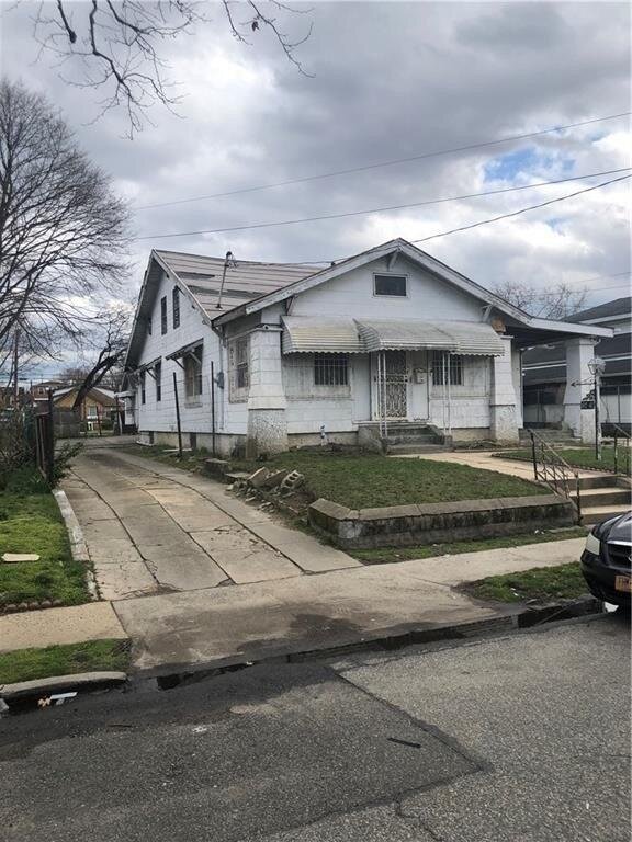
187-40 Hilburn Ave, Saint Albans, NY 11412 is a Single Family Home built in 1915. This property was last sold for $520,000 in 2006 and currently has an estimated value of $979,300. According to the Saint Albans public records, the property at 187-40 Hilburn Ave, Saint Albans, NY 11412 has approximately 1,754 square feet, with a lot size of 6,000 square feet. Nearby schools include Ps Is 116 William C Hughley, Ps 360 and Ps 134 Hollis.
Property facts
Primary Land Use and Tax Lot Information
for 187-40 Hilburn Ave

Property Tax History
for 187-40 Hilburn Ave
| Year | Taxes | |
|---|---|---|
| 2024 | $6,647 | $45,420 |
| 2023 | $6,341 | $45,900 |
Sold Homes
near 187-40 Hilburn Ave
| Address | Price | Beds | Baths |
|---|---|---|---|
|
Jamaica, NY 11433SF
|
$725,000
04/08/2025
|
3
|
3
|
|
Hollis, NY 11423SF
|
$450,000
01/21/2025
|
4
|
3
|
|
Jamaica, NY 11434SF
|
$950,000
06/11/2025
|
3
|
2
|
|
Saint Albans, NY 11412SF
|
$790,000
02/05/2025
|
4
|
3
|
|
Saint Albans, NY 11412SF
|
$840,000
01/14/2025
|
4
|
4
|
Homes For Sale
near 187-40 Hilburn Ave
| Address | Price | Beds | Baths |
|---|---|---|---|
|
Hollis, NY 11423SF
|
$875,000
52 days ago
|
3
|
2
|
|
Addisleigh Park, NY 11434SF
|
$875,000
13 days ago
|
4
|
2
|
|
Jamaica, NY 11432SF
|
$1,499,000
33 days ago
|
3
|
3
|
|
Saint Albans, NY 11433SF
|
$718,888
58 days ago
|
4
|
2
|
|
Saint Albans, NY 11412SF
|
$725,000
44 days ago
|
4
|
3
|
Home Value
for 187-40 Hilburn Ave
Estimated values are not a substitute for professional expertise. Contact your RE agent for a market assessment.
Schools
serving 187-40 Hilburn Ave
| School Name | Rating |
|---|---|
|
90-20 191st. Street, Hollis, NY 11423
|
— |
|
107-25 WREN PL, Queens, NY 11433
|
4 / 10 |
|
188-04 91ST AVE, Queens, NY 11423
|
4 / 10 |
Data provided by
GreatSchools.org © 2025. All Rights Reserved.
School service boundaries are intended to be used as reference only.
To verify enrollment eligibility for a property, contact the school directly.
Flood Factor
for 187-40 Hilburn Ave
5
|10
Major

FEMA Zone (Est.)
X (unshaded)
Flood insurance:
Recommended
Flood risks are increasing as sea levels rise and weather patterns change.
This property has a
Major Flood Factor
.
Flood Factor data provided by FloodFactor.