19 Laurel Ave, Staten Island, NY 10304 Richmond County Last Updated: April 12, 2024
Pre-Foreclosure: Lis Pendens, Estimated Market Value $530,000
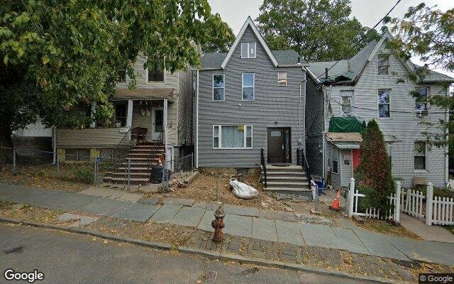
Description: 19 Laurel Ave, Staten Island, NY 10304 is a Single Family Home built in 1923. This property was last sold for $200,000 in 2007 and currently has an estimated value of $530,000. According to the Staten Island public records, the property at 19 Laurel Ave, Staten Island, NY 10304 has approximately 1,134 square feet, with a lot size of 2,933 square feet. Nearby schools include Ps 57 Hubert H Humphrey and Ps 78.
1,134 sqft
2,933 lot size
3 beds
1 baths
Year Built: 1923
Pre-foreclosure
19 Laurel Ave, Staten Island, NY 10304
Last Updated: April 12, 2024
1
Single Family Home
Town House
Estimated Market Value EMV $ 530,000
19 Laurel Ave
bool(false)

bool(true)

bool(true)

int(0)
Estimated Market Value EMV $ 530,000
Foreclosure History
for 19 Laurel Ave
for 19 Laurel Ave
Type
Single Family Home
Town House
19 Laurel Ave, Staten Island, NY 10304 is a Single Family Home built in 1923. This property was last sold for $200,000 in 2007 and currently has an estimated value of $530,000. According to the Staten Island public records, the property at 19 Laurel Ave, Staten Island, NY 10304 has approximately 1,134 square feet, with a lot size of 2,933 square feet. Nearby schools include Ps 57 Hubert H Humphrey and Ps 78.
Property features
Full Bathrooms:
Full Bathrooms:
1
1
Main Bath:
Main Bath:
Full Bath
Full Bath
Master Bedroom:
Master Bedroom:
Shared Bath
Shared Bath
Ownership Type:
Ownership Type:
Fee Simple
Fee Simple
Dining Room:
Dining Room:
Combination
Combination
Kitchen:
Kitchen:
Eat In
Eat In
Living Room:
Living Room:
Combination
Combination
Electric:
Electric:
110
110
Heat Source:
Heat Source:
Gas
Gas
Heat System:
Heat System:
Hot Water
Hot Water
No. of Heating Units:
No. of Heating Units:
1
1
Lot Dimensions:
Lot Dimensions:
23.42X125.25
23.42X125.25
Siding:
Siding:
Asbestos, Wood
Asbestos, Wood
Style:
Style:
Colonial
Colonial
Year Built Description:
Year Built Description:
Approx
Approx
Area Name:
Area Name:
Stapleton
Stapleton
Block:
Block:
00567
00567
Condition:
Condition:
Poor
Poor
County:
County:
Richmond
Richmond
Section:
Section:
North Shore
North Shore
Tax ID#:
Tax ID#:
00567-0002
00567-0002
Zoning:
Zoning:
R3 A
R3 A
Building Class:
A1
One Family Dwellings: Two Stories Detached (Small Or Moderate Size, With Or Without Attic)
Floors on Main Building:
2.5
Building Dimensions:
20'
Actual Square Footage:
1,134
Calculated Square Footage:
1,500
Residential Floor Area:
1,134
Basement:
Below grade full basement
Address:
19 LAUREL AVENUE
Borough:
Staten Island (5)
Land Use:
01
One & Two Family Buildings
Lot Dimensions:
23.42'
Calculated Lot Perimeter:
301.54 ft
Zoning Districts:
R3A
Lower-density residence district
Max Residential FAR:
0.50
Max Residential Sqft:
1,467
Buildable Residential Sqft:
333
Residential Area Distribution:
Assessed Land Value:
$8,820
Assessed Total Value:
$30,540
Last Recording Date:
Jan 8, 2024
Property Assessment Data:
Tax Class:
1
One- to three-unit residential properties
Taxable Assessed Value:
$17,215
Estimated Market Value by NYC DOF :
$509,000
Community District (CD):
501
City Council District:
49
Document DateDocument Type Unit Amount
Date
Event
Price
Price/Sqft
Source
Sep 7, 2007
Sold
$200,000
$176
Public Record
Dec 5, 1990
Sold
$100,000
$88
Public Record
Year
Taxes
Land
Additions
Total Assessment
2022
$3,451
$8,820
$15,240
$24,060
2021
$3,432
$8,820
$12,000
$20,820
2020
$2,742
$7,020
$9,000
$16,020
2019
$2,563
$7,020
$8,460
$15,480
2018
$1,995
$4,380
$5,160
$9,540
2017
$2,061
$4,368
$5,744
$10,112
2016
$1,907
$4,380
$5,160
$9,540
2015
$2,046
$3,055
$7,409
$10,464
2014
$1,729
$3,930
$5,384
$9,314
2014
$1,891
$3,465
$6,407
$9,872
2012
$1,599
$7,009
$1,778
$8,787
2010
$1,514
$7,175
$1,612
$8,787
2009
$1,405
$7,078
$1,642
$8,720
2007
$1,130
$5,499
$1,824
$7,323
Address
Price
Built
Beds
Baths
Sqft
Lot Size
Distance
145 Fulton St
Staten Island, NY 10304SF
$355,000
12/11/2023
1920
3
2
1,102
-32difference
3,000
0.14 mi
510 Weser Ave
Staten Island, NY 10304SF
$783,000
11/21/2023
2013
3
2
1,170
+36
2,250
0.97 mi
171 Clifton Ave
Staten Island, NY 10305SF
$500,000
04/16/2024
1965
3
3
1,184
+50
2,400
0.92 mi
321 Glen Ave
Staten Island, NY 10301SF
$470,000
11/10/2023
1993
3
3
1,080
-54
2,596
0.96 mi
23 Steuben St
Staten Island, NY 10304SF
$515,000
11/20/2023
1910
3
3
1,200
+66
1,875
0.60 mi
121 Fulton St
Staten Island, NY 10304SF
$449,000
04/12/2024
1901
3
2
972
-162
3,090
0.16 mi
19 Park Ln
Staten Island, NY 10301SF
$1,135,000
03/22/2024
1960
3
4
3,152
+2,018
7,697
0.20 mi
294 Howard Ave
Staten Island, NY 10301SF
$1,900,000
01/19/2024
1935
7
6
5,275
+4,141
13,888
0.27 mi
131 Roff St
Staten Island, NY 10304SF
$393,000
02/28/2024
1960
3
3
900
-234
5,544
0.33 mi
95 Pleasant Valley Ave
Staten Island, NY 10304SF
$525,000
02/05/2024
1940
4
2
1,760
+626
2,650
0.38 mi
Address
Price
Built
Beds
Baths
Sqft
Lot Size
Distance
53 School Rd
Staten Island, NY 10305SF
$669,000
54 days ago
1965
3
2
1,140
+6difference
3,124
1.49 mi
53 School Rd
Staten Island, NY 10305SF
$669,000
54 days ago
1965
3
2
1,140
+6
3,124
1.49 mi
106 Montgomery Ave
Staten Island, NY 10301SF
$370,000
7 days ago
1930
3
3
1,120
-14
2,125
1.37 mi
179 Lamport Blvd
Staten Island, NY 10305SF
$799,999
24 days ago
1965
4
3
1,120
-14
2,280
1.84 mi
26 Evelyn Pl
Staten Island, NY 10305SF
$749,999
45 days ago
1960
3
2
1,150
+16
5,402
1.34 mi
10 Xenia St
Staten Island, NY 10305SF
$685,000
49 days ago
1960
3
2
1,108
-26
2,199
1.96 mi
125 Raritan Ave
Staten Island, NY 10304SF
$775,000
27 days ago
1935
2
2
1,160
+26
5,000
1.96 mi
10 Xenia St
Staten Island, NY 10305SF
$685,000
49 days ago
1960
3
2
1,108
-26
2,199
1.96 mi
259 Morrison Ave
Staten Island, NY 10310SF
$549,999
41 days ago
1920
3
2
1,168
+34
3,500
1.68 mi
77 City Blvd
Staten Island, NY 10301SF
$99,000
40 days ago
1940
3
1
1,176
+42
4,599
1.16 mi
Estimated values are not a substitute for professional expertise. Contact your RE agent for a market assessment.
School Name
Rating
Grades
Parent Rating
Distance
Notre Dame Academy Elementary
, Staten Island , NY 10301
—
PK−8
0.67 mi
Ps 57 Hubert H Humphrey
, Staten Island , NY 10304
4 / 10
K−5
0.63 mi
Ps 78
, Staten Island , NY 10304
3 / 10
K−5
0.35 mi
Immaculate Conception School
, Staten Island , NY 10304
—
K−8
0.30 mi
Notre Dame Academy High School
, Staten Island , NY 10301
—
9−12
0.60 mi
Concord High School
, Staten Island , NY 10304
2 / 10
9−12
0.64 mi
EAGLE ACADEMY OF STATEN ISLAND
, Staten Island , NY 10304
4 / 10
6−12
0.22 mi
Is 49 Bertha A Dreyfus
, Staten Island , NY 10304
4 / 10
6−8
0.21 mi
FEMA Zone (Est.)
X (unshaded)
Flood insurance:
Recommended
Flood risks are increasing as sea levels rise and weather patterns change.
This property has a
Minimal Flood Factor
.
Please Log In
Please wait... If this message is not eventually replaced by the proper contents of the document, your PDF viewer may not be able to display this type of document.
You can upgrade to the latest version of Adobe Reader for Windows®, Mac, or Linux® by visiting
https://get.adobe.com/reader/ this link .
For more assistance with Adobe Reader visit
http://get.adobe.com/reader/ this link .
You can download this PDF-document from
here .