197-15 91st Rd, Hollis, NY 11423 Queens County Last Updated: March 6, 2024
Foreclosure: Estimated Market Value $939,400
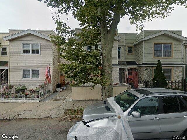
Description: 197-15 91st Rd, Hollis, NY 11423 is a Multi Family Home built in 1920. This property was last sold for $200,000 in 2000 and currently has an estimated value of $939,400. According to the Hollis public records, the property at 197-15 91st Rd, Hollis, NY 11423 has approximately 1,936 square feet, with a lot size of 3,576 square feet. Nearby schools include Ps 134 Hollis, P.S. 35 Nathaniel Woodhull and The Bellaire School.
1,936 sqft
3,576 lot size
Year Built: 1920
Foreclosure
197-15 91st Rd, Hollis, NY 11423
Last Updated: March 6, 2024
1
Multi Family Home
Estimated Market Value EMV $ 939,400
197-15 91st Rd
bool(false)

bool(true)

bool(true)

int(0)
Estimated Market Value EMV $ 939,400
for 197-15 91st Rd
Estimated Reasonable Offer
$ 760,900
197-15 91st Rd, Hollis, NY 11423 is a Multi Family Home built in 1920. This property was last sold for $200,000 in 2000 and currently has an estimated value of $939,400. According to the Hollis public records, the property at 197-15 91st Rd, Hollis, NY 11423 has approximately 1,936 square feet, with a lot size of 3,576 square feet. Nearby schools include Ps 134 Hollis, P.S. 35 Nathaniel Woodhull and The Bellaire School.
Property facts
Property features
Year Built:
Year Built:
1920
1920
Living Area:
Living Area:
1936
1936
Building Class:
B2
Two Family Dwellings: Frame
Floors on Main Building:
2
Building Dimensions:
20'
Actual Square Footage:
1,936
Calculated Square Footage:
1,680
Residential Floor Area:
1,936
Basement:
Below grade full basement
Land Use:
01
One & Two Family Buildings
Calculated Lot Perimeter:
346.98 ft
Irregular Lot:
An irregularly shaped lot
Zoning Districts:
R4
Lower-density residence district
Max Residential FAR:
0.75
Max Residential Sqft:
2,682
Buildable Residential Sqft:
746
Residential Area Distribution:
Assessed Land Value:
$17,880
Assessed Total Value:
$50,940
Last Recording Date:
Jan 8, 2024
Property Assessment Data:
Tax Class:
1
One- to three-unit residential properties
Taxable Assessed Value:
$32,069
Estimated Market Value by NYC DOF :
$869,000
Community District (CD):
412
City Council District:
23
Document DateDocument Type Unit Amount
Date
Event
Price
Price/Sqft
Source
Jul 7, 2000
Sold
$200,000
$103
Public Record
Year
Taxes
Land
Additions
Total Assessment
2022
$6,040
$17,880
$30,960
$48,840
2021
$6,318
$17,880
$27,240
$45,120
2020
$5,995
$17,880
$20,940
$38,820
2019
$5,590
$17,880
$23,220
$41,100
2018
$5,274
$11,613
$13,601
$25,214
2017
$5,139
$12,544
$12,670
$25,214
2016
$5,002
$11,297
$13,724
$25,021
2015
$4,616
$13,804
$9,801
$23,605
2014
$4,266
$13,701
$8,569
$22,270
2013
$4,032
$15,524
$5,488
$21,012
2011
$3,620
$14,489
$6,523
$21,012
2010
$3,084
$14,530
$6,321
$20,851
2009
$2,935
$13,207
$6,464
$19,671
2007
$2,503
$2,962
$14,548
$17,510
Address
Price
Built
Beds
Baths
Sqft
Lot Size
Distance
88-49 205th St
Jamaica, NY 11423MF
$900,000
12/04/2023
1930
4
4
1,700
-236difference
3,400
0.38 mi
91-20 193rd St
Jamaica, NY 11423MF
$1,150,000
02/13/2024
1925
5
3
2,530
+594
5,613
0.32 mi
89-54 214th St
Queens Village, NY 11427MF
$795,000
12/13/2023
1920
4
2
1,325
-611
2,450
0.92 mi
199-12 Hollis Ave
Saint Albans, NY 11412MF
$656,250
11/13/2023
1930
4
3
2,760
+824
2,440
0.62 mi
Address
Price
Built
Beds
Baths
Sqft
Lot Size
Distance
11405 Ovid Pl
Saint Albans, NY 11412MF
$800,000
168 days ago
1930
5
3
1,966
+30difference
3,920
1.23 mi
194-29 111th Rd
Saint Albans, NY 11412MF
$775,000
87 days ago
1930
4
2
1,888
-48
4,000
0.84 mi
109-26 174th St
Jamaica, NY 11433MF
$849,999
29 days ago
1925
5
3
2,002
+66
2,700
1.50 mi
217-22 102nd Ave
Jamaica, NY 11429MF
$859,000
7 days ago
1930
5
3
1,838
-98
3,920
1.13 mi
198-16 109th Ave
Hollis, NY 11412MF
$775,000
16 days ago
1935
3
2
1,836
-100
3,620
0.55 mi
99-10 218 St
Queens Village, NY 11429MF
$1,095,000
115 days ago
2024
4
4
1,800
-136
2,800
1.26 mi
214-59 Whitehall Ter
Queens Village, NY 11427MF
$1,190,000
25 days ago
1940
4
2
2,080
+144
4,000
1.09 mi
16519 Chapin Ct
Jamaica, NY 11432MF
$1,150,000
107 days ago
1920
7
2
2,111
+175
3,920
2.00 mi
203-19 100th Ave
Hollis, NY 11423MF
$725,000
105 days ago
1935
4
3
1,742
-194
3,800
0.37 mi
Estimated values are not a substitute for professional expertise. Contact your RE agent for a market assessment.
School Name
Rating
Grades
Parent Rating
Distance
Is 238 Susan B Anthony
, Queens , NY 11423
4 / 10
6−8
0.96 mi
Is 192 The Linden
, SAINT ALBANS , NY 11412
3 / 10
6−8
0.76 mi
Pathways College Preparatory School: A College Board School
, Queens , NY 11412
4 / 10
6−12
0.78 mi
Ps 134 Hollis
, Queens , NY 11423
3 / 10
K−5
0.60 mi
BENJAMIN FRANKLIN HIGH SCHOOL FOR FINANCE AND INFORMATION TECHNOLOGY
, Queens , NY 11411
3 / 10
9−12
—
1.37 mi
Cambria Heights Academy
, Queens , NY 11423
3 / 10
9−12
—
0.50 mi
P.S. 35 Nathaniel Woodhull
, Queens , NY 11423
8 / 10
K−5
0.37 mi
Wellspring Elementary & Middle
, Hollis , NY 11423
—
K−8
0.39 mi
The Bellaire School
, Queens , NY 11427
6 / 10
K−5
0.49 mi
Helping Hand Academy II
, Queens , NY 11423
—
K−1
—
0.38 mi
FEMA Zone (Est.)
X (unshaded)
Flood insurance:
Recommended
Flood risks are increasing as sea levels rise and weather patterns change.
This property has a
Severe Flood Factor
.
Please Log In
Please wait... If this message is not eventually replaced by the proper contents of the document, your PDF viewer may not be able to display this type of document.
You can upgrade to the latest version of Adobe Reader for Windows®, Mac, or Linux® by visiting
https://get.adobe.com/reader/ this link .
For more assistance with Adobe Reader visit
http://get.adobe.com/reader/ this link .
You can download this PDF-document from
here .