2018 New York Ave, Brooklyn, NY 11210 Kings County Last Updated: January 26, 2024
Pre-Foreclosure: Lis Pendens, Estimated Market Value $984,600
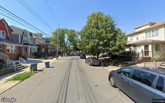
Description: 2018 New York Ave, Brooklyn, NY 11210 is a Single Family Home built in 1925. This property was last sold for $620,000 in 2015 and currently has an estimated value of $984,600. According to the Brooklyn public records, the property at 2018 New York Ave, Brooklyn, NY 11210 has approximately 1,352 square feet, with a lot size of 2,000 square feet. Nearby schools include Ps 193 Gil Hodges, Ps 207 Elizabeth G Leary, Ps 119 Amersfort and Ps 222 Katherine R Snyder.
1,352 sqft
2,000 lot size
Year Built: 1925
Pre-foreclosure
2018 New York Ave, Brooklyn, NY 11210
Last Updated: January 26, 2024
1
Single Family Home
Town House
Estimated Market Value EMV $ 984,600
2018 New York Ave
bool(false)

bool(true)

bool(true)

int(0)
Estimated Market Value EMV $ 984,600
Foreclosure History
for 2018 New York Ave
for 2018 New York Ave
Type
Single Family Home
Town House
2018 New York Ave, Brooklyn, NY 11210 is a Single Family Home built in 1925. This property was last sold for $620,000 in 2015 and currently has an estimated value of $984,600. According to the Brooklyn public records, the property at 2018 New York Ave, Brooklyn, NY 11210 has approximately 1,352 square feet, with a lot size of 2,000 square feet. Nearby schools include Ps 193 Gil Hodges, Ps 207 Elizabeth G Leary, Ps 119 Amersfort and Ps 222 Katherine R Snyder.
Property features
Mls Area Major:
Mls Area Major:
Flatlands
Flatlands
Building Class:
A9
One Family Dwellings: Miscellaneous
Floors on Main Building:
2
Building Dimensions:
13'
Actual Square Footage:
1,352
Calculated Square Footage:
1,196
Residential Floor Area:
1,352
Basement:
Below grade full basement
Address:
2018 NEW YORK AVENUE
BIN
Name 2018 NEW YORK AVENUE
Land Use:
01
One & Two Family Buildings
Calculated Lot Perimeter:
244.85 ft
Zoning Districts:
R4
Lower-density residence district
Max Residential FAR:
0.75
Max Residential Sqft:
1,500
Buildable Residential Sqft:
148
Residential Area Distribution:
Assessed Land Value:
$11,100
Assessed Total Value:
$51,960
Last Recording Date:
Jan 8, 2024
Property Assessment Data:
Tax Class:
1
One- to three-unit residential properties
Taxable Assessed Value:
$34,824
Estimated Market Value by NYC DOF :
$783,000
Community District (CD):
318
City Council District:
45
Document DateDocument Type Unit Amount
Date
Event
Price
Price/Sqft
Source
Aug 31, 2016
Listing removed
$389,000
$651
Brooklyn
Nov 10, 2015
Sold
$620,000
$459
Public Record
Jan 17, 2002
Sold
$342,500
$253
Public Record
Sep 18, 1992
Sold
$210,000
$155
Public Record
Jul 1, 1987
Sold
$155,000
$115
Public Record
Year
Taxes
Land
Additions
Total Assessment
2022
$6,265
$11,100
$37,140
$48,240
2021
$6,605
$11,100
$38,400
$49,500
2020
$6,503
$11,100
$36,840
$47,940
2019
$6,070
$11,100
$38,340
$49,440
2018
$5,771
$8,339
$19,249
$27,588
2017
$5,331
$6,815
$19,339
$26,154
2016
$4,918
$7,717
$18,437
$26,154
2015
$4,697
$10,980
$14,623
$25,603
2014
$4,328
$8,821
$15,363
$24,184
2013
$4,112
$9,778
$13,212
$22,990
2012
$3,674
$13,196
$8,599
$21,795
2010
$3,369
$14,184
$7,611
$21,795
2009
$3,208
$12,919
$8,417
$21,336
2007
$2,604
$3,541
$14,622
$18,163
Address
Price
Built
Beds
Baths
Sqft
Lot Size
Distance
1822 Madison Pl
Brooklyn, NY 11229SF
$780,000
01/03/2024
1930
3
3
1,352
2,000
1.00 mi
1074 E 37th St
Brooklyn, NY 11210SF
$475,000
03/29/2024
1925
3
2
1,344
-8difference
2,000
0.52 mi
1796 Schenectady Ave
Brooklyn, NY 11234SF
$790,000
03/29/2024
1925
3
3
1,376
+24
2,033
0.75 mi
3031 Avenue R
Brooklyn, NY 11229SF
$995,000
11/15/2023
1920
3
2
1,386
+34
3,200
0.95 mi
1509 E 48th St
Brooklyn, NY 11234SF
$525,000
02/12/2024
1935
3
1
1,316
-36
2,000
0.76 mi
1922 New York Ave
Brooklyn, NY 11210SF
$670,000
01/23/2024
1925
3
1
1,428
+76
2,000
0.16 mi
3410 Kings Hwy
Brooklyn, NY 11234SF
$740,000
12/13/2023
1945
3
3
2,065
+713
2,032
0.30 mi
3622 Flatlands Ave
Brooklyn, NY 11234SF
$675,000
12/13/2023
1925
3
2
1,472
+120
1,845
0.41 mi
1514 E 36th St
Brooklyn, NY 11234SF
$877,000
01/25/2024
1935
3
3
1,552
+200
2,400
0.44 mi
3396 Bedford Ave
Brooklyn, NY 11210SF
$1,420,000
03/26/2024
1996
3
3
1,618
+266
2,500
0.45 mi
Address
Price
Built
Beds
Baths
Sqft
Lot Size
Distance
1349 E 65th St
Brooklyn, NY 11234SF
$424,000
14 days ago
1925
2
2
1,338
-14difference
4,800
1.47 mi
2065 Brown St
Brooklyn, NY 11229SF
$935,400
38 days ago
1940
3
2
1,366
+14
2,083
1.53 mi
449 E 34th St
Brooklyn, NY 11203SF
$509,600
46 days ago
1910
3
1
1,328
-24
1,123
1.56 mi
2514 Quentin Rd
Brooklyn, NY 11229SF
$899,000
51 days ago
1925
3
2
1,376
+24
2,667
1.00 mi
2036 Stuart St
Brooklyn, NY 11229SF
$1,050,000
15 days ago
1950
3
2
1,320
-32
2,000
1.33 mi
2019 Avenue V
Brooklyn, NY 11229SF
$969,000
13 days ago
1925
3
2
1,320
-32
1,950
1.81 mi
1638 Ryder St
Brooklyn, NY 11234SF
$805,000
34 days ago
1930
3
2
1,316
-36
2,000
0.60 mi
1383 E 34th St
Brooklyn, NY 11210SF
$859,000
19 days ago
1925
3
2
1,316
-36
2,000
0.14 mi
2049 Gerritsen Ave
Brooklyn, NY 11229SF
$780,000
76 days ago
1950
3
2
1,392
+40
2,217
1.36 mi
3316 Farragut Rd
East Flatbush, NY 11203SF
$965,000
76 days ago
1920
3
2
1,404
+52
2,000
0.90 mi
Estimated values are not a substitute for professional expertise. Contact your RE agent for a market assessment.
School Name
Rating
Grades
Parent Rating
Distance
Step-Special Torah Education Program
, Brooklyn , NY 11204
—
—
0.14 mi
Yad Yisroel
, Brooklyn , NY 11210
—
—
—
0.13 mi
Ps 193 Gil Hodges
, Brooklyn , NY 11210
8 / 10
K−5
0.37 mi
Mesivta Tiferes Yisroel
, Brooklyn , NY 11210
—
K−12
—
0.12 mi
Ps 207 Elizabeth G Leary
, Brooklyn , NY 11234
7 / 10
K−8
0.97 mi
Ps 119 Amersfort
, Brooklyn , NY 11210
5 / 10
K−5
0.31 mi
Is 381
, Brooklyn , NY 11210
8 / 10
6−8
0.17 mi
Andries Hudde School
, Brooklyn , NY 11210
5 / 10
6−8
0.18 mi
Ps 222 Katherine R Snyder
, Brooklyn , NY 11234
9 / 10
K−5
0.71 mi
Midwood High School
, Brooklyn , NY 11210
7 / 10
9−12
0.81 mi
FEMA Zone (Est.)
X (unshaded)
Flood insurance:
Recommended
Flood risks are increasing as sea levels rise and weather patterns change.
This property has a
Minimal Flood Factor
.
Please Log In
Please wait... If this message is not eventually replaced by the proper contents of the document, your PDF viewer may not be able to display this type of document.
You can upgrade to the latest version of Adobe Reader for Windows®, Mac, or Linux® by visiting
https://get.adobe.com/reader/ this link .
For more assistance with Adobe Reader visit
http://get.adobe.com/reader/ this link .
You can download this PDF-document from
here .