2212 Manning St, Bronx, NY 10462 Bronx County Last Updated: April 12, 2024
Pre-Foreclosure: Lis Pendens, Estimated Market Value $698,000
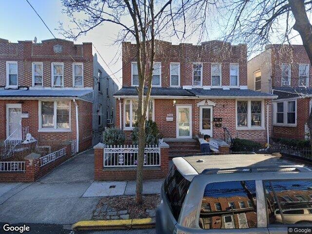
Description: 2212 Manning St, Bronx, NY 10462 is a Single Family Home built in 1920. This property was last sold for $155,000 in 2001 and currently has an estimated value of $698,000. According to the Bronx public records, the property at 2212 Manning St, Bronx, NY 10462 has approximately 1,504 square feet, with a lot size of 1,897 square feet. Nearby schools include Linden Tree Elementary School, Ps 106 Parkchester and Ps Ms 194.
1,504 sqft
1,897 lot size
Year Built: 1920
Pre-foreclosure
2212 Manning St, Bronx, NY 10462
Last Updated: April 12, 2024
1
Single Family Home
Town House
Estimated Market Value EMV $ 698,000
2212 Manning St
bool(false)

bool(true)

bool(true)

int(0)
Estimated Market Value EMV $ 698,000
Foreclosure History
for 2212 Manning St
for 2212 Manning St
Type
Single Family Home
Town House
2212 Manning St, Bronx, NY 10462 is a Single Family Home built in 1920. This property was last sold for $155,000 in 2001 and currently has an estimated value of $698,000. According to the Bronx public records, the property at 2212 Manning St, Bronx, NY 10462 has approximately 1,504 square feet, with a lot size of 1,897 square feet. Nearby schools include Linden Tree Elementary School, Ps 106 Parkchester and Ps Ms 194.
Property features
Year Built:
Year Built:
1920
1920
Living Area:
Living Area:
1504
1504
Building Class:
A1
One Family Dwellings: Two Stories Detached (Small Or Moderate Size, With Or Without Attic)
Floors on Main Building:
2.00
Building Dimensions:
16.42'
Actual Square Footage:
1,504
Calculated Square Footage:
1,314
Residential Floor Area:
1,504
Basement:
Below grade full basement
Address:
2212 MANNING STREET
BIN
Name 2212 MANNING STREET
Land Use:
01
One & Two Family Buildings
Lot Dimensions:
20'
Calculated Lot Perimeter:
231.66 ft
Zoning Districts:
R6
Moderate-density residence district
Max Residential FAR:
2.43
Max Residential Sqft:
4,610
Buildable Residential Sqft:
3,106
Residential Area Distribution:
Assessed Land Value:
$7,380
Assessed Total Value:
$39,840
Last Recording Date:
Jan 8, 2024
Property Assessment Data:
Tax Class:
1
One- to three-unit residential properties
Taxable Assessed Value:
$26,784
Estimated Market Value by NYC DOF :
$637,000
Community District (CD):
210
City Council District:
18
Document DateDocument Type Unit Amount
Date
Event
Price
Price/Sqft
Source
Jul 20, 2001
Sold
$155,000
$103
Public Record
Jun 14, 1999
Sold
$102,000
$68
Public Record
Year
Taxes
Land
Additions
Total Assessment
2022
$5,191
$7,380
$27,840
$35,220
2021
$5,203
$7,380
$22,500
$29,880
2020
$4,937
$7,380
$25,560
$32,940
2019
$4,669
$7,380
$20,640
$28,020
2018
$4,594
$5,674
$16,286
$21,960
2017
$4,417
$6,566
$15,106
$21,672
2016
$4,119
$6,795
$13,811
$20,606
2015
$3,801
$8,040
$11,400
$19,440
2015
$3,563
$8,040
$10,560
$18,600
2014
$3,212
$13,320
$4,980
$18,300
2011
$3,231
$12,223
$7,268
$19,491
2010
$3,073
$12,223
$7,268
$19,491
2009
$2,879
$12,221
$7,101
$19,322
2007
$2,307
$3,492
$12,751
$16,243
Address
Price
Built
Beds
Baths
Sqft
Lot Size
Distance
815 Havemeyer Ave
Bronx, NY 10473SF
$560,000
03/14/2024
—
3
2
1,420
-84difference
2,642
0.91 mi
2152 Hermany Ave
Bronx, NY 10473SF
$665,000
02/09/2024
1935
3
2
1,762
+258
5,121
0.87 mi
2316 Newbold Ave
Bronx, NY 10462SF
$765,000
01/30/2024
—
6
3
1,805
+301
2,721
0.31 mi
1231 Puritan Ave
Bronx, NY 10461SF
$510,000
04/23/2024
—
2
2
954
-550
4,646
0.99 mi
2063 Turnbull Ave
Bronx, NY 10473SF
$695,000
03/04/2024
1940
3
3
2,172
+668
2,060
0.91 mi
1949 Benedict Ave
Bronx, NY 10462SF
$999,900
03/07/2024
1930
7
4
3,617
+2,113
4,302
0.42 mi
Address
Price
Built
Beds
Baths
Sqft
Lot Size
Distance
3187 Rawlins Ave
Bronx, NY 10465SF
$665,000
31 days ago
1925
3
2
1,512
+8difference
2,736
1.54 mi
1232 Mayflower Ave
Bronx, NY 10461SF
$649,000
86 days ago
1920
3
2
1,539
+35
2,513
1.09 mi
2898 Zulette Ave
Bronx, NY 10461SF
$629,000
188 days ago
1925
3
2
1,450
-54
2,374
1.03 mi
1852 Tomlinson Ave
Bronx, NY 10461SF
$599,000
47 days ago
1910
3
2
1,440
-64
2,500
1.01 mi
2541 Colden Ave
Bronx, NY 10469SF
$1,175,000
173 days ago
1920
3
1
1,600
+96
5,000
1.92 mi
1235 Rhinelander Ave
Bronx, NY 10461SF
$799,000
49 days ago
1940
3
2
1,400
-104
5,475
1.21 mi
1236 Rhinelander Ave
Bronx, NY 10461SF
$729,000
35 days ago
1940
3
2
1,400
-104
2,500
1.18 mi
2319 Bruner Ave
Bronx, NY 10469SF
$739,000
7 days ago
1965
3
2
1,612
+108
2,740
1.81 mi
Estimated values are not a substitute for professional expertise. Contact your RE agent for a market assessment.
School Name
Rating
Grades
Parent Rating
Distance
St Raymond High School For Boys
, The Bronx , NY 10462
—
9−12
0.14 mi
Linden Tree Elementary School
, The Bronx , NY 10462
5 / 10
K−5
—
0.13 mi
Jhs 127 The Castle Hill
, The Bronx , NY 10462
5 / 10
6−8
0.16 mi
Ps 106 Parkchester
, The Bronx , NY 10462
4 / 10
K−5
0.17 mi
Santa Maria School
, The Bronx , NY 10462
—
PK−8
0.19 mi
St. Raymond Boys High School
, Bronx , NY 10462
—
9−12
0.12 mi
Ps Ms 194
, The Bronx , NY 10462
6 / 10
K−8
0.30 mi
Herbert H Lehman High School
, The Bronx , NY 10461
4 / 10
8−12
0.69 mi
Bronx High School For The Visual Arts
, The Bronx , NY 10462
4 / 10
9−12
1.21 mi
Urban Assembly Charter - Computer Science
, The Bronx , NY 10472
7 / 10
9−11
1.45 mi
FEMA Zone (Est.)
X (unshaded)
Flood insurance:
Recommended
Flood risks are increasing as sea levels rise and weather patterns change.
This property has a
Minimal Flood Factor
.
Please Log In
Please wait... If this message is not eventually replaced by the proper contents of the document, your PDF viewer may not be able to display this type of document.
You can upgrade to the latest version of Adobe Reader for Windows®, Mac, or Linux® by visiting
https://get.adobe.com/reader/ this link .
For more assistance with Adobe Reader visit
http://get.adobe.com/reader/ this link .
You can download this PDF-document from
here .