224 Amber St, Brooklyn, NY 11208 Kings County Last Updated: October 23, 2023
Foreclosure: Estimated Market Value $607,900
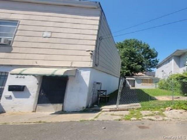
Description: 224 Amber St, Brooklyn, NY 11208 is a Single Family Home built in 1930. This property was last sold for $140,000 in 2004 and currently has an estimated value of $607,900. According to the Brooklyn public records, the property at 224 Amber St, Brooklyn, NY 11208 has approximately 612 square feet, with a lot size of 2,000 square feet. Nearby schools include Ps 224 Hale A Woodruff, Our World Neighborhood Charter 2 and Ps 214 Michael Friedsam.
612 sqft
2,000 lot size
1 beds
1 baths
Year Built: 1930
Foreclosure
224 Amber St, Brooklyn, NY 11208
Last Updated: October 23, 2023
1
Single Family Home
Town House
Estimated Market Value EMV $ 607,900
224 Amber St
bool(false)

bool(true)

bool(true)

int(0)
Estimated Market Value EMV $ 607,900
for 224 Amber St
Estimated Reasonable Offer
$ 480,200
Type
Single Family Home
Town House
224 Amber St, Brooklyn, NY 11208 is a Single Family Home built in 1930. This property was last sold for $140,000 in 2004 and currently has an estimated value of $607,900. According to the Brooklyn public records, the property at 224 Amber St, Brooklyn, NY 11208 has approximately 612 square feet, with a lot size of 2,000 square feet. Nearby schools include Ps 224 Hale A Woodruff, Our World Neighborhood Charter 2 and Ps 214 Michael Friedsam.
Property facts
Property features
Flooring:
Flooring:
Carpeting
Carpeting
Electric:
Electric:
220 V
220 V
Full Bathrooms:
Full Bathrooms:
1
1
Total Bathrooms:
Total Bathrooms:
1.00
1.00
Lot Size Acres:
Lot Size Acres:
0.0459137
0.0459137
Lot Size Dimensions:
Lot Size Dimensions:
20 x 100
20 x 100
Lot Size Square Feet:
Lot Size Square Feet:
2000
2000
Construction Materials:
Construction Materials:
Wood Frame
Wood Frame
Foundation Details:
Foundation Details:
Block
Block
House Style:
House Style:
Ranch
Ranch
Levels or Stories:
Levels or Stories:
1
1
Total Square Feet Living:
Total Square Feet Living:
680
680
Annual Tax Amount:
Annual Tax Amount:
100.00
100.00
Area:
Area:
East New York
East New York
County:
County:
Kings (Brooklyn)
Kings (Brooklyn)
Lot Number:
Lot Number:
17
17
Parcel Number:
Parcel Number:
044730017
044730017
Property Subtype:
Property Subtype:
Single Family
Single Family
Source Listing Status:
Source Listing Status:
Sold
Sold
Source Neighborhood:
Source Neighborhood:
East New York
East New York
Source Property Type:
Source Property Type:
Residential
Residential
Source System Name:
Source System Name:
C2C
C2C
Building Class:
A2
One Family Dwellings: One Story (Permanent Living Quarters)
Floors on Main Building:
1
Building Dimensions:
17'
Actual Square Footage:
612
Calculated Square Footage:
680
Residential Floor Area:
612
Address:
224 AMBER STREET
Land Use:
01
One & Two Family Buildings
Calculated Lot Perimeter:
243.67 ft
Zoning Districts:
R4
Lower-density residence district
Max Residential FAR:
0.75
Max Residential Sqft:
1,500
Buildable Residential Sqft:
888
Residential Area Distribution:
Assessed Land Value:
$7,200
Assessed Total Value:
$25,800
Last Recording Date:
Jan 8, 2024
Property Assessment Data:
Tax Class:
1
One- to three-unit residential properties
Taxable Assessed Value:
$4,278
Estimated Market Value by NYC DOF :
$430,000
Community District (CD):
305
City Council District:
42
Document DateDocument Type Unit Amount
Recorded DateDocument Type Unit Amount
Date
Event
Price
Price/Sqft
Source
Mar 13, 2024
Sold
$139,650
$228
Public Record
Nov 10, 2004
Sold
$140,000
$206
Brooklyn
Year
Taxes
Land
Additions
Total Assessment
2022
$805
$7,200
$20,520
$27,720
2021
$842
$7,200
$14,220
$21,420
2020
$799
$7,200
$10,680
$17,880
2019
$745
$7,200
$9,000
$16,200
2018
$703
$1,115
$2,249
$3,364
2017
$685
$1,382
$1,982
$3,364
2016
$666
$1,488
$1,848
$3,336
2015
$615
$1,803
$1,345
$3,148
2014
$569
$1,702
$1,269
$2,971
2013
$538
$1,606
$1,198
$2,804
2012
$510
$1,833
$971
$2,804
2010
$448
$1,810
$971
$2,781
2009
$423
$1,744
$880
$2,624
2007
$360
$415
$1,922
$2,337
Address
Price
Built
Beds
Baths
Sqft
Lot Size
Distance
133-14 86th St
Ozone Park, NY 11417SF
$650,000
11/02/2023
1935
2
2
861
+249difference
2,142
0.47 mi
135-22 95th St
Ozone Park, NY 11417SF
$650,000
03/29/2024
1925
3
3
1,065
+453
2,000
0.91 mi
84-19 Sutter Ave
Jamaica, NY 11417SF
$665,000
03/29/2024
1930
3
1
1,092
+480
1,800
0.50 mi
90-11 156th Ave
Howard Beach, NY 11414SF
$815,000
04/15/2024
1960
3
3
1,125
+513
4,000
0.92 mi
327 Crescent St
Brooklyn, NY 11208SF
$670,000
11/03/2023
2022
3
2
1,164
+552
1,617
0.97 mi
135-30 94th St
Ozone Park, NY 11417SF
$705,000
01/12/2024
1935
4
2
1,536
+924
2,204
0.86 mi
158-05 83rd St
Howard Beach, NY 11414SF
$860,000
04/05/2024
1950
4
3
1,610
+998
5,000
0.93 mi
Address
Price
Built
Beds
Baths
Sqft
Lot Size
Distance
708 Ashford St
Brooklyn, NY 11207SF
$475,000
55 days ago
1925
—
—
625
+13difference
—
1.32 mi
705 Eldert Ln
Brooklyn, NY 11208SF
$650,000
4 days ago
1910
1
1
640
+28
4,000
0.28 mi
Estimated values are not a substitute for professional expertise. Contact your RE agent for a market assessment.
School Name
Rating
Grades
Parent Rating
Distance
Ps 224 Hale A Woodruff
, Brooklyn , NY 11208
5 / 10
K−5
0.57 mi
Our World Neighborhood Charter 2
, Queens , NY 11414
3 / 10
K−4
0.17 mi
Spring Creek Community School
, Brooklyn , NY 11239
4 / 10
6−12
—
1.23 mi
Academy for Young Writers
, Brooklyn , NY 11208
4 / 10
6−12
—
1.23 mi
Transit Tech Career and Technical Education High School
, Brooklyn , NY 11208
3 / 10
9−12
1.05 mi
Ps 214 Michael Friedsam
, Brooklyn , NY 11208
6 / 10
K−5
0.44 mi
Robert F Kennedy Incentive Pro
, Brooklyn , NY 11208
—
6−8
0.46 mi
St Helen School
, Queens , NY 11414
—
PK−8
0.80 mi
Jhs 218 James P Sinnott
, Brooklyn , NY 11208
4 / 10
6−8
0.82 mi
Van Siclen Community Middle School
, Brooklyn , NY 11207
3 / 10
6−8
1.61 mi
FEMA Zone (Est.)
X (unshaded)
Flood insurance:
Recommended
Flood risks are increasing as sea levels rise and weather patterns change.
This property has a
Severe Flood Factor
.
Please Log In
Please wait... If this message is not eventually replaced by the proper contents of the document, your PDF viewer may not be able to display this type of document.
You can upgrade to the latest version of Adobe Reader for Windows®, Mac, or Linux® by visiting
https://get.adobe.com/reader/ this link .
For more assistance with Adobe Reader visit
http://get.adobe.com/reader/ this link .
You can download this PDF-document from
here .