2267 62nd St, Brooklyn, NY 11204 Kings County Last Updated: April 18, 2024
Pre-Foreclosure: Lis Pendens, Estimated Market Value $1,273,700
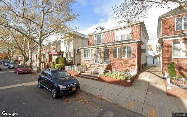
Description: 2267 62nd St, Brooklyn, NY 11204 is a Multi Family Home built in 1930. This property was last sold for $572,400 in 2005 and currently has an estimated value of $1,273,700. According to the Brooklyn public records, the property at 2267 62nd St, Brooklyn, NY 11204 has approximately 1,376 square feet, with a lot size of 1,983 square feet. Nearby schools include Ps 177 The Marlboro, Ps 226 Alfred De B Mason and Ps 121 Nelson A Rockefeller.
1,376 sqft
1,983 lot size
Year Built: 1930
Pre-foreclosure
2267 62nd St, Brooklyn, NY 11204
Last Updated: April 18, 2024
1
Multi Family Home
Estimated Market Value EMV $ 1,273,700
2267 62nd St
bool(false)

bool(true)

bool(true)

int(0)
Estimated Market Value EMV $ 1,273,700
Foreclosure History
for 2267 62nd St
for 2267 62nd St
Last Sold
$572.4K in 2005
2267 62nd St, Brooklyn, NY 11204 is a Multi Family Home built in 1930. This property was last sold for $572,400 in 2005 and currently has an estimated value of $1,273,700. According to the Brooklyn public records, the property at 2267 62nd St, Brooklyn, NY 11204 has approximately 1,376 square feet, with a lot size of 1,983 square feet. Nearby schools include Ps 177 The Marlboro, Ps 226 Alfred De B Mason and Ps 121 Nelson A Rockefeller.
Property features
Year Built:
Year Built:
1930
1930
Zoning:
Zoning:
R4-1
R4-1
Living Area:
Living Area:
1376
1376
Building Class:
B3
Two Family Dwellings: Converted From One Family
Floors on Main Building:
2
Building Dimensions:
16'
Actual Square Footage:
1,376
Calculated Square Footage:
1,280
Residential Floor Area:
1,376
Basement:
Below grade full basement
Land Use:
01
One & Two Family Buildings
Lot Dimensions:
19.83'
Calculated Lot Perimeter:
250.07 ft
Zoning Districts:
R4-1
Lower-density residence district
Max Residential FAR:
0.75
Max Residential Sqft:
1,487
Buildable Residential Sqft:
111
Residential Area Distribution:
Assessed Land Value:
$16,920
Assessed Total Value:
$51,180
Last Recording Date:
Jan 8, 2024
Property Assessment Data:
Tax Class:
1
One- to three-unit residential properties
Taxable Assessed Value:
$39,812
Estimated Market Value by NYC DOF :
$853,000
Community District (CD):
311
City Council District:
44
Document DateDocument Type Unit Amount
Date
Event
Price
Price/Sqft
Source
May 23, 2005
Sold
$572,400
$416
Public Record
Year
Taxes
Land
Additions
Total Assessment
2022
$7,371
$16,920
$33,060
$49,980
2021
$7,331
$16,920
$37,920
$54,840
2020
$7,373
$16,920
$39,900
$56,820
2019
$6,940
$16,920
$37,740
$54,660
2018
$6,822
$10,393
$22,223
$32,616
2017
$6,272
$10,492
$20,278
$30,770
2016
$5,803
$9,746
$19,284
$29,030
2015
$5,676
$12,213
$16,817
$29,030
2014
$5,297
$13,958
$13,690
$27,648
2013
$5,216
$16,021
$11,159
$27,180
2012
$4,668
$15,229
$10,413
$25,642
2010
$4,133
$13,261
$10,931
$24,192
2009
$3,937
$16,569
$7,623
$24,192
2007
$3,298
$3,340
$18,029
$21,369
Address
Price
Built
Beds
Baths
Sqft
Lot Size
Distance
1876 60th St
Brooklyn, NY 11204MF
$1,550,000
04/16/2024
1920
3
3
1,472
+96difference
1,800
0.58 mi
1665 E 8th St
Brooklyn, NY 11223MF
$1,160,000
03/29/2024
1925
4
3
1,260
-116
2,500
0.83 mi
1865 78th St
Brooklyn, NY 11214MF
$839,000
01/05/2024
1920
3
2
1,216
-160
1,667
0.99 mi
2057 63rd St
Brooklyn, NY 11204MF
$1,400,000
12/12/2023
1925
5
3
1,600
+224
2,300
0.31 mi
2034 64th St
Brooklyn, NY 11204MF
$1,155,000
03/28/2024
1915
—
3
1,600
+224
2,300
0.37 mi
6308 23rd Ave
Brooklyn, NY 11204MF
$1,697,000
12/29/2023
—
—
4
3,200
+1,824
2,500
0.08 mi
1385 Dahill Rd
Brooklyn, NY 11204MF
$999,000
11/17/2023
1930
5
3
1,944
+568
1,572
0.16 mi
1431 Dahill Rd
Brooklyn, NY 11204MF
$1,520,000
01/04/2024
1930
7
4
2,840
+1,464
2,575
0.21 mi
2126 62nd St
Brooklyn, NY 11204MF
$1,599,000
03/15/2024
1920
7
5
2,560
+1,184
2,500
0.22 mi
2106 61st St
Brooklyn, NY 11204MF
$1,850,000
02/15/2024
1930
5
3
2,720
+1,344
2,500
0.25 mi
Address
Price
Built
Beds
Baths
Sqft
Lot Size
Distance
1775 64th St
Brooklyn, NY 11204MF
$1,299,888
45 days ago
1925
4
3
1,356
-20difference
1,840
0.73 mi
1859 82nd St
Brooklyn, NY 11214MF
$1,239,000
121 days ago
1930
6
3
1,400
+24
2,000
1.16 mi
8005 13th Ave
Brooklyn, NY 11228MF
$2,600,000
152 days ago
1910
—
4
1,344
-32
6,000
1.71 mi
26 Bay 41st St
Brooklyn, NY 11214MF
$1,100,000
1439 days ago
1925
4
4
1,428
+52
1,933
1.33 mi
1799 W 7th St
Brooklyn, NY 11223MF
$1,980,000
45 days ago
1955
—
3
1,430
+54
2,800
0.78 mi
2074 61st St
Brooklyn, NY 11204MF
$1,890,000
56 days ago
1925
7
3
1,320
-56
2,500
0.29 mi
1633 77th St
Brooklyn, NY 11214MF
$1,299,888
54 days ago
1930
1
2
1,308
-68
2,399
1.22 mi
1069 E 15th St
Brooklyn, NY 11230MF
$899,000
67 days ago
—
—
3
1,446
+70
1,250
1.08 mi
1129 60th St
Brooklyn, NY 11219MF
$2,100,000
758 days ago
1925
3
2
1,304
-72
4,007
1.70 mi
6314 24th Ave
Brooklyn, NY 11204MF
$1,899,000
487 days ago
—
—
4
1,449
+73
2,600
0.19 mi
Estimated values are not a substitute for professional expertise. Contact your RE agent for a market assessment.
School Name
Rating
Grades
Parent Rating
Distance
Bishop Kearney High School
, Brooklyn , NY 11204
—
9−12
0.10 mi
Saint Athanasius School
, Brooklyn , NY 11204
—
K−8
0.13 mi
Edward R Murrow High School
, Brooklyn , NY 11230
4 / 10
9−12
1.03 mi
Bais Esther School
, Brooklyn , NY 11204
—
10−12
—
0.24 mi
Ps 177 The Marlboro
, Brooklyn , NY 11204
7 / 10
K−5
0.47 mi
Ps 226 Alfred De B Mason
, Brooklyn , NY 11204
8 / 10
K−8
0.06 mi
James Madison High School
, Brooklyn , NY 11229
4 / 10
9−12
1.59 mi
Ps 121 Nelson A Rockefeller
, Brooklyn , NY 11204
8 / 10
K−8
0.56 mi
I.S. 96 Seth Low
, Brooklyn , NY 11204
7 / 10
6−8
0.61 mi
Brooklyn Studio Secondary School
, Brooklyn , NY 11214
6 / 10
6−12
1.12 mi
FEMA Zone (Est.)
X (unshaded)
Flood insurance:
Recommended
Flood risks are increasing as sea levels rise and weather patterns change.
This property has a
Minimal Flood Factor
.
Please Log In
Please wait... If this message is not eventually replaced by the proper contents of the document, your PDF viewer may not be able to display this type of document.
You can upgrade to the latest version of Adobe Reader for Windows®, Mac, or Linux® by visiting
https://get.adobe.com/reader/ this link .
For more assistance with Adobe Reader visit
http://get.adobe.com/reader/ this link .
You can download this PDF-document from
here .