31-03 Mott Ave, Far Rockaway, NY 11691 Queens County Last Updated: October 27, 2023
Pre-Foreclosure: Lis Pendens, Estimated Market Value $1,542,400
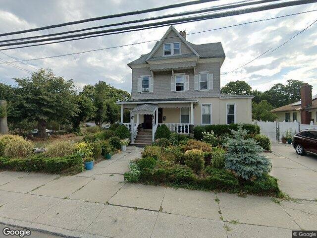
Description: 31-03 Mott Ave, Far Rockaway, NY 11691 is a Multi Family Home built in 1920. This property was last sold for $344,500 in 2002 and currently has an estimated value of $1,542,400. According to the Far Rockaway public records, the property at 31-03 Mott Ave, Far Rockaway, NY 11691 has approximately 4,214 square feet, with a lot size of 8,832 square feet. Nearby schools include Ps 104 The Bays Water, Wave Preparatory Elementary School and Challenge Preparatory Charter School.
4,214 sqft
8,832 lot size
Year Built: 1920
Pre-foreclosure
31-03 Mott Ave, Far Rockaway, NY 11691
Last Updated: October 27, 2023
1
Multi Family Home
Estimated Market Value EMV $ 1,542,400
31-03 Mott Ave
bool(false)

bool(true)

bool(true)

int(0)
Estimated Market Value EMV $ 1,542,400
Foreclosure History
for 31-03 Mott Ave
for 31-03 Mott Ave
Last Sold
$344.5K in 2002
31-03 Mott Ave, Far Rockaway, NY 11691 is a Multi Family Home built in 1920. This property was last sold for $344,500 in 2002 and currently has an estimated value of $1,542,400. According to the Far Rockaway public records, the property at 31-03 Mott Ave, Far Rockaway, NY 11691 has approximately 4,214 square feet, with a lot size of 8,832 square feet. Nearby schools include Ps 104 The Bays Water, Wave Preparatory Elementary School and Challenge Preparatory Charter School.
Property features
Year Built:
Year Built:
1920
1920
Zoning:
Zoning:
R1-2
R1-2
Living Area:
Living Area:
4214
4214
Building Class:
B3
Two Family Dwellings: Converted From One Family
Floors on Main Building:
2.75
Building Dimensions:
36'
Actual Square Footage:
4,214
Calculated Square Footage:
1,980
Residential Floor Area:
4,214
Basement:
Below grade full basement
Address:
31-03 MOTT AVENUE
Land Use:
01
One & Two Family Buildings
Lot Dimensions:
90'
Calculated Lot Perimeter:
387.50 ft
Irregular Lot:
An irregularly shaped lot
Zoning Districts:
R1-2
Lower-density residence district
Max Residential FAR:
0.50
Max Residential Sqft:
4,416
Buildable Residential Sqft:
202
Residential Area Distribution:
Assessed Land Value:
$15,360
Assessed Total Value:
$49,800
Last Recording Date:
Jan 8, 2024
Property Assessment Data:
Tax Class:
1
One- to three-unit residential properties
Taxable Assessed Value:
$30,954
Estimated Market Value by NYC DOF :
$785,000
Community District (CD):
414
City Council District:
31
Document DateDocument Type Unit Amount
Date
Event
Price
Price/Sqft
Source
Sep 24, 2002
Sold
$344,500
$82
Public Record
Year
Taxes
Land
Additions
Total Assessment
2022
$6,122
$15,360
$34,620
$49,980
2021
$6,092
$15,360
$32,400
$47,760
2020
$5,782
$15,360
$37,140
$52,500
2019
$5,396
$15,360
$29,580
$44,940
2018
$5,396
$12,530
$13,265
$25,795
2017
$5,209
$12,582
$12,975
$25,557
2016
$4,823
$10,191
$13,933
$24,124
2015
$4,452
$9,030
$13,737
$22,767
2014
$4,118
$8,526
$12,970
$21,496
2013
$4,125
$8,526
$12,970
$21,496
2011
$3,490
$12,916
$8,382
$21,298
2010
$3,242
$14,625
$5,479
$20,104
2009
$3,061
$12,864
$6,109
$18,973
2007
$2,739
$2,841
$14,908
$17,749
Address
Price
Built
Beds
Baths
Sqft
Lot Size
Distance
561 Beach 43rd St
Far Rockaway, NY 11691MF
$760,000
11/08/2023
2005
3
1
2,312
-1,902difference
3,305
0.79 mi
1470 Egmont Pl
Far Rockaway, NY 11691MF
$950,000
02/20/2024
1960
6
4
2,052
-2,162
13,499
0.05 mi
23-02 Cornaga Ave
Far Rockaway, NY 11691MF
$705,000
12/07/2023
1930
5
2
1,890
-2,324
6,059
0.75 mi
2225 Brookhaven Ave
Far Rockaway, NY 11691MF
$635,000
11/21/2023
1935
4
2
1,600
-2,614
3,352
0.91 mi
Address
Price
Built
Beds
Baths
Sqft
Lot Size
Distance
2345 Cornaga Ave
Far Rockaway, NY 11691SF
$818,000
223 days ago
—
6
3
4,268
+54difference
7,500
0.70 mi
59 Lawrence Ave
Lawrence, NY 11559SF
$3,100,000
306 days ago
1959
5
5
4,480
+266
16,200
1.81 mi
Estimated values are not a substitute for professional expertise. Contact your RE agent for a market assessment.
School Name
Rating
Grades
Parent Rating
Distance
Ps 104 The Bays Water
, Queens , NY 11691
6 / 10
K−5
0.22 mi
Wave Preparatory Elementary School
, Queens , NY 11691
9 / 10
K−5
—
0.88 mi
Challenge Preparatory Charter School
, Queens , NY 11691
5 / 10
K−9
0.72 mi
Queens High School For Information Research And T
, Queens , NY 11691
4 / 10
9−12
—
0.64 mi
Frederick Douglas Academy Vi High School
, Queens , NY 11691
1 / 10
9−12
—
0.63 mi
Acadey of Medical Technology - A College Board School
, Queens , NY 11691
4 / 10
6−12
0.60 mi
Mesivta Yam Hatorah
, Queens , NY 11691
—
9−12
—
0.61 mi
World Harvest Deliverance Center Christian Academy
, Queens , NY 11691
—
PK−7
—
0.61 mi
Darchei Torah
, Queens , NY 11691
—
PK−12
—
0.61 mi
Bais Yaakov Ateres Miriam
, Queens , NY 11691
—
1−5
—
0.61 mi
FEMA Zone (Est.)
X (shaded)
Flood insurance:
Recommended
Flood risks are increasing as sea levels rise and weather patterns change.
This property has a
Major Flood Factor
.
Please Log In
Please wait... If this message is not eventually replaced by the proper contents of the document, your PDF viewer may not be able to display this type of document.
You can upgrade to the latest version of Adobe Reader for Windows®, Mac, or Linux® by visiting
https://get.adobe.com/reader/ this link .
For more assistance with Adobe Reader visit
http://get.adobe.com/reader/ this link .
You can download this PDF-document from
here .