3227 Seymour Ave, Bronx, NY 10469 Bronx County Last Updated: March 5, 2024
Pre-Foreclosure: Lis Pendens, Estimated Market Value $848,600
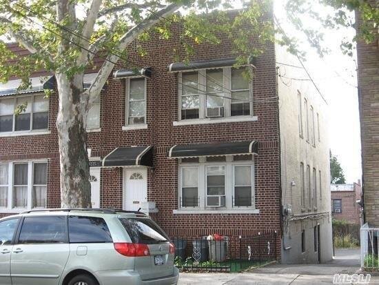
Description: 3227 Seymour Ave, Bronx, NY 10469 is a Multi Family Home built in 1920. This property was last sold for $545,000 in 2016 and currently has an estimated value of $848,600. According to the Bronx public records, the property at 3227 Seymour Ave, Bronx, NY 10469 has approximately 2,160 square feet, with a lot size of 2,500 square feet. Nearby schools include Ps 97, Ps 78 Anne Hutchinson and Ps 121 Throop.
2,160 sqft
2,500 lot size
Year Built: 1920
Pre-foreclosure
3227 Seymour Ave, Bronx, NY 10469
Last Updated: March 5, 2024
1
Multi Family Home
Estimated Market Value EMV $ 848,600
3227 Seymour Ave
bool(false)

bool(true)

bool(true)

int(0)
Estimated Market Value EMV $ 848,600
Foreclosure History
for 3227 Seymour Ave
for 3227 Seymour Ave
3227 Seymour Ave, Bronx, NY 10469 is a Multi Family Home built in 1920. This property was last sold for $545,000 in 2016 and currently has an estimated value of $848,600. According to the Bronx public records, the property at 3227 Seymour Ave, Bronx, NY 10469 has approximately 2,160 square feet, with a lot size of 2,500 square feet. Nearby schools include Ps 97, Ps 78 Anne Hutchinson and Ps 121 Throop.
Property features
Year Built:
Year Built:
1920
1920
Zoning:
Zoning:
R4-1
R4-1
Living Area:
Living Area:
2160
2160
Building Class:
B1
Two Family Dwellings: Brick
Floors on Main Building:
2.00
Building Dimensions:
20.50'
Actual Square Footage:
2,160
Calculated Square Footage:
2,214
Residential Floor Area:
2,160
Basement:
Below grade full basement
Address:
3227 SEYMOUR AVENUE
BIN
Name 3227 SEYMOUR AVENUE
Land Use:
01
One & Two Family Buildings
Calculated Lot Perimeter:
253.15 ft
Zoning Districts:
R4-1
Lower-density residence district
Max Residential FAR:
0.75
Max Residential Sqft:
1,875
Buildable Residential Sqft:
0
Residential Area Distribution:
Assessed Land Value:
$9,780
Assessed Total Value:
$43,440
Exempt Total Value:
$1,400
Last Recording Date:
Jan 8, 2024
Property Assessment Data:
Tax Class:
1
One- to three-unit residential properties
Taxable Assessed Value:
$31,842
Estimated Market Value by NYC DOF :
$724,000
Community District (CD):
212
City Council District:
12
Document DateDocument Type Unit Amount
Date
Event
Price
Price/Sqft
Source
Jan 15, 2016
Sold
$545,000
$252
Public Record
Oct 13, 2015
Listing removed
$569,999
$264
OneKeyMLS
Aug 24, 2015
Listed
$569,999
$264
OneKeyMLS
Apr 24, 2015
Sold
$258,100
$119
Public Record
Apr 17, 2014
Listing removed
$229,000
—
MyStateMLS
Sep 16, 2013
Listed
$229,000
—
MyStateMLS
Sep 6, 2012
Listing removed
$429,000
$199
HudsonGatewayMLSEast
May 31, 2012
Listed
$429,000
$199
HudsonGatewayMLSEast
Aug 31, 2010
Listing removed
$479,000
$222
HudsonGatewayMLSEast
May 18, 2010
Relisted
$479,000
$222
HudsonGatewayMLSEast
Apr 20, 2010
Listing removed
$500,000
$226
HudsonGatewayMLSEast
Apr 13, 2010
Listing removed
$479,000
$222
HudsonGatewayMLSEast
Mar 26, 2010
Listed
$479,000
$222
HudsonGatewayMLSEast
Dec 19, 2009
Listed
$500,000
$226
HudsonGatewayMLSEast
Oct 4, 2001
Sold
$312,500
$145
Public Record
Jan 24, 2001
Sold
$180,500
$84
Public Record
Year
Taxes
Land
Additions
Total Assessment
2022
$5,685
$9,780
$35,940
$45,720
2021
$5,643
$9,780
$33,000
$42,780
2020
$5,678
$9,780
$30,600
$40,380
2019
$5,502
$9,780
$23,640
$33,420
2018
$5,223
$7,313
$19,113
$26,426
2017
$4,782
$7,682
$17,249
$24,931
2016
$4,392
$9,780
$13,740
$23,520
2015
$4,660
$9,357
$14,475
$23,832
2015
$4,422
$9,453
$13,632
$23,085
2014
$4,282
$13,582
$8,732
$22,314
2011
$3,615
$15,120
$4,740
$19,860
2010
$3,259
$15,120
$4,740
$19,860
2009
$3,051
$12,412
$7,979
$20,391
2007
$2,610
$2,847
$15,354
$18,201
Address
Price
Built
Beds
Baths
Sqft
Lot Size
Distance
3978 Paulding Ave
Bronx, NY 10466MF
$838,000
02/23/2024
—
6
2
2,124
-36difference
3,434
0.87 mi
761 S Oak Dr
Bronx, NY 10467MF
$725,000
03/01/2024
—
4
2
2,846
+686
4,600
0.92 mi
933 E 217th St
Bronx, NY 10469MF
$800,000
12/12/2023
1925
5
3
3,208
+1,048
5,921
0.68 mi
1705 Hammersley Ave
Bronx, NY 10469MF
$620,000
02/16/2024
1901
10
5
3,936
+1,776
3,607
0.37 mi
Address
Price
Built
Beds
Baths
Sqft
Lot Size
Distance
3214 Seymour Ave
Bronx, NY 10469MF
$879,000
118 days ago
1920
8
2
2,160
2,500
0.04 mi
3709 Paulding Ave
Bronx, NY 10469MF
$950,000
91 days ago
1935
7
2
2,193
+33difference
—
0.61 mi
2540 Colden Ave
Bronx, NY 10469MF
$879,000
41 days ago
1958
4
3
2,125
-35
2,548
0.87 mi
1027 E 222nd St
Bronx, NY 10469MF
$825,000
83 days ago
1955
6
4
2,125
-35
1,980
0.72 mi
3212 Paulding Ave
Bronx, NY 10469MF
$750,000
142 days ago
1945
6
2
2,120
-40
2,500
0.56 mi
4055 Pratt Ave
Bronx, NY 10466MF
$545,000
20 days ago
1925
4
2
2,110
-50
5,214
1.52 mi
2931 Wickham Ave
Bronx, NY 10469MF
$849,000
92 days ago
2003
6
3
2,100
-60
2,375
0.55 mi
4040 Pratt Ave
Bronx, NY 10466MF
$750,000
35 days ago
1958
4
2
2,095
-65
2,500
1.51 mi
1653 Yates Ave
Bronx, NY 10461MF
$1,395,000
13 days ago
1924
—
—
2,084
-76
4,792
1.67 mi
801 S Oak Dr
Bronx, NY 10467MF
$900,000
169 days ago
1920
4
3
2,250
+90
3,990
0.80 mi
Estimated values are not a substitute for professional expertise. Contact your RE agent for a market assessment.
School Name
Rating
Grades
Parent Rating
Distance
Ps 97
, The Bronx , NY 10469
4 / 10
K−5
0.69 mi
Holy Rosary School
, Bronx , NY 10469
—
K−8
0.46 mi
Bronx Lab School
, The Bronx , NY 10467
2 / 10
8−12
0.77 mi
High School of Contemporary Arts
, The Bronx , NY 10467
1 / 10
9−12
0.75 mi
Bronx Academy Of Health Careers
, The Bronx , NY 10467
3 / 10
9−12
0.74 mi
Bronx Aerospace High School
, The Bronx , NY 10467
2 / 10
9−12
0.74 mi
Academy of Learning
, Bronx , NY 10469
—
K−3
0.15 mi
Ps 78 Anne Hutchinson
, The Bronx , NY 10469
5 / 10
K−5
0.42 mi
Jhs 144 Michelangelo
, The Bronx , NY 10469
6 / 10
6−8
0.86 mi
Ps 121 Throop
, The Bronx , NY 10469
3 / 10
K−5
0.45 mi
FEMA Zone (Est.)
X (unshaded)
Flood insurance:
Recommended
Flood risks are increasing as sea levels rise and weather patterns change.
This property has a
Minimal Flood Factor
.
Please Log In
Please wait... If this message is not eventually replaced by the proper contents of the document, your PDF viewer may not be able to display this type of document.
You can upgrade to the latest version of Adobe Reader for Windows®, Mac, or Linux® by visiting
https://get.adobe.com/reader/ this link .
For more assistance with Adobe Reader visit
http://get.adobe.com/reader/ this link .
You can download this PDF-document from
here .