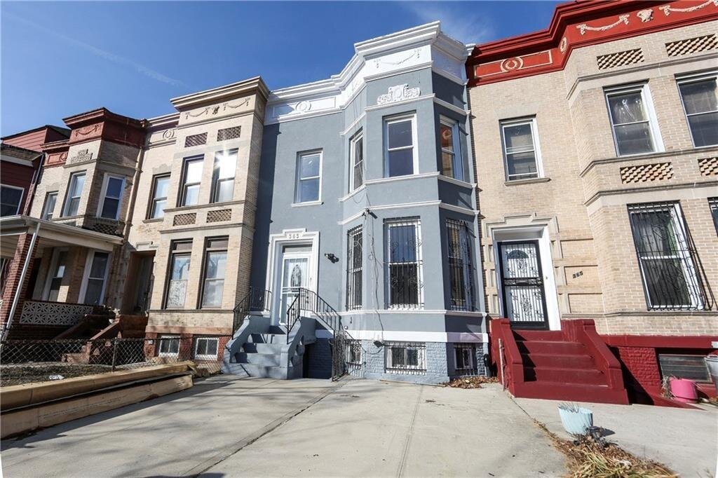
363 Hawthorne St, Brooklyn, NY 11225 Kings County Last Updated: April 11, 2024
For Sale: Estimated Market Value $1,332,900
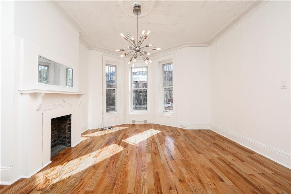
Description: 363 Hawthorne St, Brooklyn, NY 11225 is a Single Family Home built in 1899. This property was last sold for $995,000 in 2018 and currently has an estimated value of $1,332,900. According to the Brooklyn public records, the property at 363 Hawthorne St, Brooklyn, NY 11225 has approximately 1,848 square feet, with a lot size of 3,298 square feet. Nearby schools include Achievement First Voyager Charter, Ps 92 Adrian Hegeman and Ps 397 Foster Laurie.
1,848 sqft
3,298 lot size
3 beds
4 baths
Year Built: 1899
Hot Deal
363 Hawthorne St, Brooklyn, NY 11225
Last Updated: April 11, 2024
2
Single Family Home
Town House
Estimated Market Value EMV $ 1,332,900
363 Hawthorne St
bool(false)

bool(true)

bool(true)

int(0)
Estimated Market Value EMV $ 1,332,900
The Hot Deal section reflects only properties processed within the last 10 days and it is renewing on a daily basis.
for 363 Hawthorne St
Type
Single Family Home
Town House
363 Hawthorne St, Brooklyn, NY 11225 is a Single Family Home built in 1899. This property was last sold for $995,000 in 2018 and currently has an estimated value of $1,332,900. According to the Brooklyn public records, the property at 363 Hawthorne St, Brooklyn, NY 11225 has approximately 1,848 square feet, with a lot size of 3,298 square feet. Nearby schools include Achievement First Voyager Charter, Ps 92 Adrian Hegeman and Ps 397 Foster Laurie.
Property features
Heating Features:
Heating Features:
Gas
Gas
Flooring:
Flooring:
Ceramic, Hardwood
Ceramic, Hardwood
Total Rooms:
Total Rooms:
8
8
Electric:
Electric:
Circuit Breakers
Circuit Breakers
Yard:
Yard:
Back, Front
Back, Front
Lot Size Acres:
Lot Size Acres:
0.0757117
0.0757117
Lot Size Square Feet:
Lot Size Square Feet:
3298
3298
1/2 Bathrooms:
1/2 Bathrooms:
2
2
Full Bathrooms:
Full Bathrooms:
2
2
Total Bathrooms:
Total Bathrooms:
4.00
4.00
Construction Materials:
Construction Materials:
Block
Block
Foundation Details:
Foundation Details:
Block
Block
House Style:
House Style:
Duplex
Duplex
Levels or Stories:
Levels or Stories:
2
2
Property Age:
Property Age:
121
121
Total Square Feet Living:
Total Square Feet Living:
1848
1848
Year Built:
Year Built:
1899
1899
Annual Tax Amount:
Annual Tax Amount:
4023.00
4023.00
Area:
Area:
Lefferts Garden
Lefferts Garden
County:
County:
Kings (Brooklyn)
Kings (Brooklyn)
Lot Number:
Lot Number:
60
60
Property Subtype:
Property Subtype:
Single Family
Single Family
Property Subtype:
Property Subtype:
townhouse
townhouse
Source Listing Status:
Source Listing Status:
Pending
Pending
Source Neighborhood:
Source Neighborhood:
Lefferts Garden
Lefferts Garden
Source Property Type:
Source Property Type:
Residential
Residential
Source System Name:
Source System Name:
C2C
C2C
Building Class:
A5
One Family Dwellings: Attached Or Semi-detached
Floors on Main Building:
2
Building Dimensions:
20'
Actual Square Footage:
1,848
Calculated Square Footage:
1,600
Residential Floor Area:
1,848
Basement:
Below grade full basement
Address:
363 HAWTHORNE STREET
BIN
Name 363 HAWTHORNE STREET
Land Use:
01
One & Two Family Buildings
Lot Dimensions:
20'
Calculated Lot Perimeter:
367.16 ft
Zoning Districts:
R6
Moderate-density residence district
Max Residential FAR:
2.43
Max Residential Sqft:
8,014
Buildable Residential Sqft:
6,166
Residential Area Distribution:
Assessed Land Value:
$31,320
Assessed Total Value:
$82,500
Last Recording Date:
Jan 8, 2024
Property Assessment Data:
Tax Class:
1
One- to three-unit residential properties
Taxable Assessed Value:
$26,582
Estimated Market Value by NYC DOF :
$1,375,000
Community District (CD):
309
City Council District:
40
Document DateDocument Type Unit Amount
Date
Event
Price
Price/Sqft
Source
Apr 11, 2024
Listing removed
—
—
MyStateMLS
Sep 19, 2023
Listed
$700,000
—
MyStateMLS
Jan 5, 2021
Listing removed
—
—
Brooklyn
Mar 17, 2020
Listing removed
$1,295,000
$701
MyStateMLS
Nov 11, 2019
Relisted
$1,295,000
$701
Brooklyn
Nov 2, 2019
Listing removed
—
—
Brooklyn
Sep 4, 2019
Relisted
$1,295,000
$701
Brooklyn
Sep 2, 2019
Listing removed
—
—
Brooklyn
Jun 17, 2019
Price Changed
$1,299,000
$703
Brooklyn
Jun 6, 2019
Price Changed
$1,349,000
$730
Brooklyn
May 9, 2019
Price Changed
$1,399,000
$757
Brooklyn
Apr 3, 2019
Listed
$1,450,000
$785
MyStateMLS
Feb 19, 2019
Listed
$1,450,000
$785
Brooklyn
Mar 1, 2018
Sold
$995,000
$538
Public Record
Aug 22, 2007
Sold
$845,000
$457
Public Record
Aug 23, 2006
Sold
$625,000
$338
Public Record
Year
Taxes
Land
Additions
Total Assessment
2022
$4,727
$31,320
$52,860
$84,180
2021
$4,704
$31,320
$42,840
$74,160
2020
$4,727
$31,320
$30,660
$61,980
2019
$4,634
$31,320
$27,480
$58,800
2018
$4,372
$10,491
$10,410
$20,901
2017
$4,022
$12,609
$7,126
$19,735
2016
$3,724
$16,074
$2,556
$18,630
2015
$3,639
$11,994
$6,618
$18,612
2014
$3,536
$13,473
$4,987
$18,460
2013
$3,342
$11,783
$5,635
$17,418
2012
$2,993
$11,689
$4,757
$16,446
2010
$2,650
$10,945
$4,580
$15,525
2009
$2,628
$8,751
$6,759
$15,510
2007
$2,115
$1,218
$12,487
$13,705
Address
Price
Built
Beds
Baths
Sqft
Lot Size
Distance
284 Sullivan Pl
Brooklyn, NY 11225SF
$1,120,000
04/04/2024
1920
4
3
1,740
-108difference
2,000
0.46 mi
379 Hawthorne St
Brooklyn, NY 11225SF
$1,200,000
12/13/2023
1899
3
1
1,640
-208
2,000
0.03 mi
145 Maple St
Brooklyn, NY 11225SF
$1,850,000
01/26/2024
1910
3
2
2,168
+320
2,000
0.43 mi
154 Sullivan Pl
Brooklyn, NY 11225SF
$1,195,000
02/06/2024
1925
4
2
1,425
-423
2,217
0.56 mi
884 Brooklyn Ave
Brooklyn, NY 11203SF
$600,000
11/20/2023
1920
3
3
1,344
-504
2,033
0.47 mi
509 Midwood St
Brooklyn, NY 11225SF
$940,000
03/07/2024
1899
3
2
1,024
-824
2,200
0.30 mi
882 Albany Ave
Brooklyn, NY 11203SF
$430,000
03/25/2024
1920
3
1
1,328
-520
1,925
0.62 mi
1441 Union St
Crown Heights, NY 11213SF
$2,400,000
11/08/2023
1901
5
3
2,466
+618
2,494
0.77 mi
213 E 43rd St
Brooklyn, NY 11203SF
$650,000
11/27/2023
1920
3
3
2,432
+584
2,000
0.81 mi
256 E 43rd St
Brooklyn, NY 11203SF
$407,986
03/12/2024
1920
4
1
1,120
-728
940
0.85 mi
Address
Price
Built
Beds
Baths
Sqft
Lot Size
Distance
4012 Farragut Rd
Brooklyn, NY 11210SF
$799,000
90 days ago
1920
4
2
1,836
-12difference
2,375
1.59 mi
762 E 37th St
Brooklyn, NY 11210SF
$750,000
157 days ago
1940
4
3
1,806
-42
2,200
1.42 mi
605 E 57th St
Brooklyn, NY 11234SF
$698,000
42 days ago
1960
3
3
1,800
-48
1,800
1.97 mi
3915 Clarendon Rd
Brooklyn, NY 11203SF
$720,000
31 days ago
1945
3
2
1,900
+52
2,533
1.08 mi
625 E 93rd St
Brooklyn, NY 11236SF
$650,000
39 days ago
1945
3
—
1,781
-67
2,250
1.78 mi
417 17th St
Brooklyn, NY 11215SF
$1,250,000
193 days ago
1915
3
2
1,960
+112
—
1.91 mi
217 Remsen Ave
Brooklyn, NY 11212SF
$750,000
214 days ago
1935
3
3
1,989
+141
1,800
1.14 mi
1090 E 39th St
Brooklyn, NY 11210SF
$750,000
251 days ago
1920
3
2
1,696
-152
4,000
2.00 mi
229 Monroe St
Brooklyn, NY 11216SF
$1,439,000
404 days ago
1905
4
2
2,001
+153
1,667
1.91 mi
645 E 92nd St
Brooklyn, NY 11236SF
$659,000
33 days ago
1945
3
2
1,680
-168
2,225
1.77 mi
Estimated values are not a substitute for professional expertise. Contact your RE agent for a market assessment.
School Name
Rating
Grades
Parent Rating
Distance
Mary Bobb Learning Academy
, Brooklyn , NY 11225
—
1−1
—
0.10 mi
Mary Bobb Learning Academy
, Brooklyn , NY 11225
—
K−2
0.11 mi
Bnos Chomesh
, Brooklyn , NY 11203
—
10−12
—
0.19 mi
Bnos Chomesh Academy
, Brooklyn , NY 11203
—
10−12
—
0.19 mi
Bnos Chomesh Academy
, Brooklyn , NY 11203
—
10−12
—
0.19 mi
Achievement First Voyager Charter
, Brooklyn , NY 11226
9 / 10
1−8
—
0.33 mi
Ps 92 Adrian Hegeman
, Brooklyn , NY 11226
3 / 10
K−5
0.31 mi
Ps 397 Foster Laurie
, Brooklyn , NY 11203
9 / 10
K−5
0.11 mi
High School for Public Service-Heroes of Tomorrow
, Brooklyn , NY 11203
5 / 10
9−12
0.28 mi
Brooklyn Institute for Liberal Arts
, Brooklyn , NY 11203
5 / 10
9−12
0.28 mi
FEMA Zone (Est.)
X (unshaded)
Flood insurance:
Recommended
Flood risks are increasing as sea levels rise and weather patterns change.
This property has a
Minimal Flood Factor
.
Please Log In
Please wait... If this message is not eventually replaced by the proper contents of the document, your PDF viewer may not be able to display this type of document.
You can upgrade to the latest version of Adobe Reader for Windows®, Mac, or Linux® by visiting
https://get.adobe.com/reader/ this link .
For more assistance with Adobe Reader visit
http://get.adobe.com/reader/ this link .
You can download this PDF-document from
here .