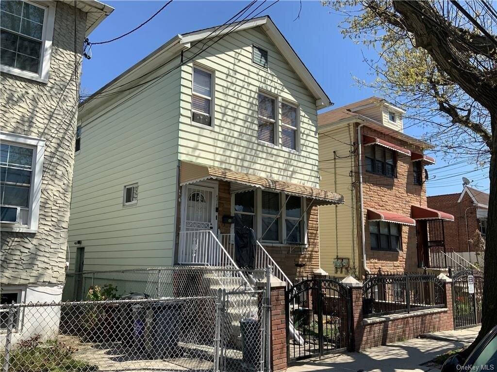
4318 Edson Ave, Bronx, NY 10466 Bronx County Last Updated: April 17, 2024
Pre-Foreclosure: Lis Pendens, Estimated Market Value $658,500
Description: 4318 Edson Ave, Bronx, NY 10466 is a Multi Family Home built in 1925. This property currently has an estimated value of $658,500. According to the Bronx public records, the property at 4318 Edson Ave, Bronx, NY 10466 has approximately 1,908 square feet, with a lot size of 2,185 square feet. Nearby schools include Ps 87, Ps 68 and Matilda Avenue School (The).
1,908 sqft
2,185 lot size
4 beds
2 baths
Year Built: 1925
Pre-foreclosure
4318 Edson Ave, Bronx, NY 10466
Last Updated: April 17, 2024
1
Multi Family Home
Estimated Market Value EMV $ 658,500
4318 Edson Ave
bool(false)

bool(true)

bool(true)

int(0)
Estimated Market Value EMV $ 658,500
Foreclosure History
for 4318 Edson Ave
for 4318 Edson Ave
4318 Edson Ave, Bronx, NY 10466 is a Multi Family Home built in 1925. This property currently has an estimated value of $658,500. According to the Bronx public records, the property at 4318 Edson Ave, Bronx, NY 10466 has approximately 1,908 square feet, with a lot size of 2,185 square feet. Nearby schools include Ps 87, Ps 68 and Matilda Avenue School (The).
Property features
Road Responsibility:
Road Responsibility:
Public Maintained Road
Public Maintained Road
Parking Features:
Parking Features:
On Street
On Street
Number of Units:
Number of Units:
2
2
Tenant Pays:
Tenant Pays:
All Utilities
All Utilities
Full Bathrooms:
Full Bathrooms:
2
2
Total Bathrooms:
Total Bathrooms:
2
2
Association:
Association:
No
No
Calculated Total Monthly Association Fees:
Calculated Total Monthly Association Fees:
0
0
Sewer:
Sewer:
Public Sewer
Public Sewer
Water Source:
Water Source:
Public
Public
Cooling Features:
Cooling Features:
Wall Unit(s)
Wall Unit(s)
Heating Features:
Heating Features:
Oil, Hot Water
Oil, Hot Water
Water Heaters:
Water Heaters:
Fuel Oil Stand Alone
Fuel Oil Stand Alone
Lot Description:
Lot Description:
Level
Level
Lot Size Acres:
Lot Size Acres:
0.0502066
0.0502066
Lot Size Square Feet:
Lot Size Square Feet:
2187
2187
Elementary School District:
Elementary School District:
City of New York
City of New York
High School District:
High School District:
City of New York
City of New York
Middle or Junior School District:
Middle or Junior School District:
City of New York
City of New York
Common Walls:
Common Walls:
No Common Walls
No Common Walls
Construction Materials:
Construction Materials:
Frame, Vinyl Siding
Frame, Vinyl Siding
Property Age:
Property Age:
97
97
Total Square Feet Living:
Total Square Feet Living:
1908
1908
Year Built Source:
Year Built Source:
Owner
Owner
Year Built:
Year Built:
1925
1925
Annual Tax Amount:
Annual Tax Amount:
6364.00
6364.00
County:
County:
Bronx
Bronx
List Price Low:
List Price Low:
799000
799000
MLS Area Minor:
MLS Area Minor:
99
99
Number of Separate Electric Meters:
Number of Separate Electric Meters:
2
2
Number of Separate Gas Meters:
Number of Separate Gas Meters:
1
1
Postal City:
Postal City:
Bronx
Bronx
Property Subtype:
Property Subtype:
Multi Family
Multi Family
Source Listing Status:
Source Listing Status:
Expired
Expired
Source Property Type:
Source Property Type:
Residential Income
Residential Income
Source System Name:
Source System Name:
C2C
C2C
Building Class:
B2
Two Family Dwellings: Frame
Floors on Main Building:
2
Building Dimensions:
18'
Actual Square Footage:
1,908
Calculated Square Footage:
2,124
Residential Floor Area:
1,908
Basement:
Below grade full basement
Address:
4318 EDSON AVENUE
Land Use:
01
One & Two Family Buildings
Lot Dimensions:
25'
Calculated Lot Perimeter:
220.37 ft
Zoning Districts:
R4
Lower-density residence district
Max Residential FAR:
0.75
Max Residential Sqft:
1,639
Buildable Residential Sqft:
0
Residential Area Distribution:
Assessed Land Value:
$8,460
Assessed Total Value:
$33,480
Last Recording Date:
Jan 8, 2024
Property Assessment Data:
Tax Class:
1
One- to three-unit residential properties
Taxable Assessed Value:
$33,480
Estimated Market Value by NYC DOF :
$558,000
Community District (CD):
212
City Council District:
12
Document DateDocument Type Unit Amount
Year
Taxes
Land
Additions
Total Assessment
2022
$6,398
$8,460
$26,580
$35,040
2021
$6,364
$8,460
$28,320
$36,780
2020
$6,400
$8,460
$23,400
$31,860
2019
$6,266
$8,460
$22,200
$30,660
2018
$5,912
$8,460
$19,800
$28,260
2017
$5,445
$7,980
$18,732
$26,712
2016
$5,037
$8,460
$16,740
$25,200
2015
$5,514
$8,962
$19,238
$28,200
2015
$5,126
$9,420
$17,340
$26,760
2014
$5,040
$15,403
$10,862
$26,265
2011
$4,278
$14,314
$9,186
$23,500
2010
$4,080
$14,314
$9,186
$23,500
2009
$3,964
$14,249
$9,251
$23,500
2007
$3,203
$3,238
$17,520
$20,758
Address
Price
Built
Beds
Baths
Sqft
Lot Size
Distance
3978 Paulding Ave
Bronx, NY 10466MF
$838,000
02/23/2024
—
6
2
2,124
+216difference
3,434
0.86 mi
3939 Amundson Ave
Bronx, NY 10466MF
$965,000
12/11/2023
2007
6
7
2,328
+420
2,500
0.68 mi
830 E 227th St
Bronx, NY 10466MF
$710,000
03/28/2024
1920
5
3
1,328
-580
2,856
0.82 mi
Address
Price
Built
Beds
Baths
Sqft
Lot Size
Distance
4346 Edson Ave
Bronx, NY 10466MF
$850,000
125 days ago
1925
5
2
1,908
2,317
0.07 mi
3333 Pearsall Ave
Bronx, NY 10469MF
$808,000
155 days ago
1950
4
3
1,905
-3difference
2,805
1.65 mi
3333 Pearsall Ave
Bronx, NY 10469MF
$808,000
155 days ago
1950
4
3
1,905
-3
2,805
1.65 mi
59 Kettell Ave
Yonkers, NY 10704MF
$750,000
12 days ago
1961
5
2
1,890
-18
3,049
1.79 mi
52 W 4th St
Mount Vernon, NY 10550MF
$525,000
29 days ago
1969
4
2
1,884
-24
—
0.63 mi
4460-4470 Van Cortlandt Park E
Bronx, NY 10470MF
$1,035,000
11 days ago
1931
5
2
1,953
+45
4,826
1.25 mi
E 233rd St and Bruner Ave
Edenwald, NY 10466MF
$749,000
247 days ago
—
4
3
1,831
-77
—
0.49 mi
2573 Flint Ave
Bronx, NY 10475MF
$831,500
87 days ago
1963
5
2
2,008
+100
—
1.55 mi
4149 Edson Ave
Bronx, NY 10466MF
$450,000
387 days ago
1920
4
2
1,805
-103
6,650
0.21 mi
2050 Pitman Ave
Bronx, NY 10466MF
$799,000
26 days ago
1945
4
3
1,800
-108
2,500
0.14 mi
Estimated values are not a substitute for professional expertise. Contact your RE agent for a market assessment.
School Name
Rating
Grades
Parent Rating
Distance
Ps 87
, The Bronx , NY 10466
5 / 10
K−5
0.11 mi
St Francis Of Assisi School
, Bronx , NY 10466
—
PK−8
0.05 mi
Mount St Michael Academy
, The Bronx , NY 10466
—
6−12
0.22 mi
Ps 68
, The Bronx , NY 10466
8 / 10
K−5
0.53 mi
Wake-Eden Christian Academy
, The Bronx , NY 10466
—
PK−5
0.55 mi
Matilda Avenue School (The)
, The Bronx , NY 10470
4 / 10
K−5
0.53 mi
Bronx Alliance Middle School
, The Bronx , NY 10466
4 / 10
6−8
—
0.80 mi
One World Middle School At Edenwald
, The Bronx , NY 10466
7 / 10
6−8
0.91 mi
Baychester Middle School
, The Bronx , NY 10466
5 / 10
6−8
—
0.93 mi
Academy for Scholarship and Entreneurship
, The Bronx , NY 10466
2 / 10
9−12
0.71 mi
FEMA Zone (Est.)
X (unshaded)
Flood insurance:
Recommended
Flood risks are increasing as sea levels rise and weather patterns change.
This property has a
Minimal Flood Factor
.
Please Log In
Please wait... If this message is not eventually replaced by the proper contents of the document, your PDF viewer may not be able to display this type of document.
You can upgrade to the latest version of Adobe Reader for Windows®, Mac, or Linux® by visiting
https://get.adobe.com/reader/ this link .
For more assistance with Adobe Reader visit
http://get.adobe.com/reader/ this link .
You can download this PDF-document from
here .