48 72nd St, Brooklyn, NY 11209 Kings County Last Updated: April 12, 2024
Pre-Foreclosure: Lis Pendens, Estimated Market Value $1,213,400
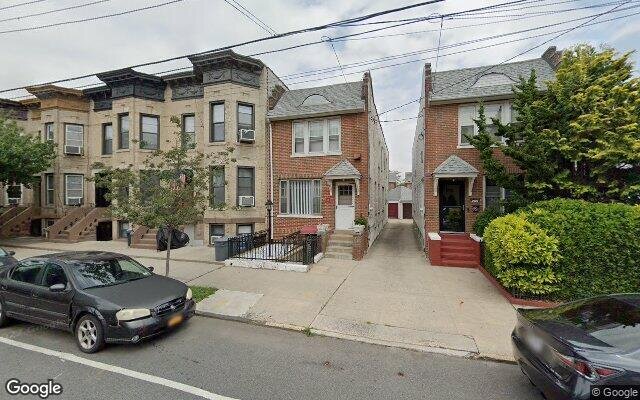
Description: 48 72nd St, Brooklyn, NY 11209 is a Single Family Home built in 1945. This property was last sold for $550,000 in 2007 and currently has an estimated value of $1,213,400. According to the Brooklyn public records, the property at 48 72nd St, Brooklyn, NY 11209 has approximately 1,500 square feet, with a lot size of 1,500 square feet. Nearby schools include Ps 102 The Bayview, Is 30 Mary White Ovington and Ps 185 Walter Kassenbrock.
1,500 sqft
1,500 lot size
Year Built: 1945
Pre-foreclosure
48 72nd St, Brooklyn, NY 11209
Last Updated: April 12, 2024
1
Single Family Home
Town House
Estimated Market Value EMV $ 1,213,400
48 72nd St
bool(false)

bool(true)

bool(true)

int(0)
Estimated Market Value EMV $ 1,213,400
Foreclosure History
for 48 72nd St
for 48 72nd St
Type
Single Family Home
Town House
48 72nd St, Brooklyn, NY 11209 is a Single Family Home built in 1945. This property was last sold for $550,000 in 2007 and currently has an estimated value of $1,213,400. According to the Brooklyn public records, the property at 48 72nd St, Brooklyn, NY 11209 has approximately 1,500 square feet, with a lot size of 1,500 square feet. Nearby schools include Ps 102 The Bayview, Is 30 Mary White Ovington and Ps 185 Walter Kassenbrock.
Property features
Year Built:
Year Built:
1945
1945
Living Area:
Living Area:
1500
1500
Building Class:
A9
One Family Dwellings: Miscellaneous
Floors on Main Building:
3
Building Dimensions:
15'
Actual Square Footage:
1,500
Calculated Square Footage:
1,395
Residential Floor Area:
1,500
Basement:
Below grade full basement
Land Use:
01
One & Two Family Buildings
Calculated Lot Perimeter:
234.74 ft
Zoning Districts:
R4A
Lower-density residence district
Special Purpose Districts:
BR
Special Bay Ridge District
Max Residential FAR:
0.75
Max Residential Sqft:
1,125
Buildable Residential Sqft:
0
Residential Area Distribution:
Assessed Land Value:
$13,380
Assessed Total Value:
$58,980
Last Recording Date:
Jan 8, 2024
Property Assessment Data:
Tax Class:
1
One- to three-unit residential properties
Taxable Assessed Value:
$41,803
Estimated Market Value by NYC DOF :
$983,000
Community District (CD):
310
City Council District:
47
Document DateDocument Type Unit Amount
Date
Event
Price
Price/Sqft
Source
Aug 31, 2016
Listing removed
$725,000
$520
Brooklyn
Jan 7, 2015
Listing removed
$999,000
$370
Brooklyn
Mar 25, 2014
Listed
$999,000
$370
Brooklyn
Oct 7, 2011
Listing removed
$950,000
$466
Brooklyn
May 9, 2011
Listed
$950,000
$466
Brooklyn
Jan 1, 2010
Listing removed
$869,000
$426
Brooklyn
Oct 20, 2009
Listed
$869,000
$426
Brooklyn
Aug 9, 2007
Sold
$550,000
$367
Public Record
May 14, 2007
Sold
$550,000
$394
Brooklyn
Aug 10, 1987
Sold
$264,000
$176
Public Record
Apr 1, 1981
Sold
$74,545
$50
Public Record
Year
Taxes
Land
Additions
Total Assessment
2022
$8,154
$13,380
$55,140
$68,520
2021
$8,236
$13,380
$54,000
$67,380
2020
$7,815
$13,380
$58,200
$71,580
2019
$7,287
$13,380
$50,760
$64,140
2018
$7,120
$9,101
$24,937
$34,038
2017
$6,938
$7,990
$26,048
$34,038
2016
$6,520
$8,370
$24,246
$32,616
2015
$6,016
$9,020
$21,750
$30,770
2014
$5,561
$10,212
$18,818
$29,030
2013
$5,144
$10,906
$17,459
$28,365
2012
$4,870
$16,227
$12,138
$28,365
2010
$4,104
$14,902
$12,278
$27,180
2009
$3,898
$15,717
$9,925
$25,642
2007
$3,648
$4,406
$19,232
$23,638
Address
Price
Built
Beds
Baths
Sqft
Lot Size
Distance
32 79th St
Brooklyn, NY 11209SF
$1,165,000
12/28/2023
1930
3
3
1,504
+4difference
2,508
0.34 mi
227 90th St
Brooklyn, NY 11209SF
$1,400,000
03/22/2024
1935
4
4
1,504
+4
2,067
0.97 mi
119 89th St
Brooklyn, NY 11209SF
$1,225,000
12/02/2023
1925
3
2
1,512
+12
2,500
0.88 mi
24 71st St
Brooklyn, NY 11209SF
$1,050,000
04/10/2024
1925
5
2
1,520
+20
2,000
0.05 mi
65 78th St
Brooklyn, NY 11209SF
$1,400,000
12/22/2023
1925
4
2
1,472
-28
2,296
0.29 mi
79 73rd St
Brooklyn, NY 11209SF
$1,150,000
02/15/2024
1915
4
2
2,080
+580
2,000
0.08 mi
107 73rd St
Brooklyn, NY 11209SF
$1,290,000
04/12/2024
1925
3
2
1,456
-44
1,431
0.13 mi
44 Bay Ridge Pkwy
Brooklyn, NY 11209SF
$1,100,000
11/17/2023
1920
4
3
1,920
+420
2,000
0.17 mi
75 Bay Ridge Pkwy
Brooklyn, NY 11209SF
$1,170,000
04/05/2024
1920
3
3
1,690
+190
2,162
0.18 mi
7316 Ridge Blvd
Brooklyn, NY 11209SF
$1,450,000
02/22/2024
1910
4
3
4,121
+2,621
3,500
0.31 mi
Address
Price
Built
Beds
Baths
Sqft
Lot Size
Distance
324 97th St
Brooklyn, NY 11209SF
$1,300,000
24 days ago
1925
6
2
1,500
2,400
1.39 mi
324 97th St
Brooklyn, NY 11209SF
$1,300,000
24 days ago
1925
6
2
1,500
2,400
1.39 mi
9111 Colonial Rd
Brooklyn, NY 11209MF
$1,385,000
101 days ago
1925
4
3
1,500
2,668
1.00 mi
651 90th St
Brooklyn, NY 11228SF
$1,088,000
36 days ago
1930
3
2
1,515
+15difference
950
1.43 mi
717 66th St
Brooklyn, NY 11220SF
$1,480,000
94 days ago
1935
5
2
1,520
+20
—
1.12 mi
944 81st St
Brooklyn, NY 11228SF
$1,100,000
19 days ago
1925
3
2
1,520
+20
2,500
1.32 mi
986 76th St
Brooklyn, NY 11228SF
$1,460,000
181 days ago
1925
3
2
1,470
-30
2,000
1.33 mi
71 78th St
Brooklyn, NY 11209SF
$1,249,000
68 days ago
1925
3
2
1,470
-30
2,296
0.30 mi
151 99th St
Brooklyn, NY 11209SF
$1,250,000
55 days ago
1925
4
1
1,536
+36
2,050
1.43 mi
1119 85th St
Brooklyn, NY 11228SF
$1,488,000
460 days ago
1910
2
3
1,464
-36
2,225
1.59 mi
Estimated values are not a substitute for professional expertise. Contact your RE agent for a market assessment.
School Name
Rating
Grades
Parent Rating
Distance
Gateway City Academy
, Brooklyn , NY 11204
—
K−5
0.47 mi
Xaverian High School
, Brooklyn , NY 11209
—
6−12
0.09 mi
Ps 102 The Bayview
, Brooklyn , NY 11209
7 / 10
K−5
0.35 mi
Is 30 Mary White Ovington
, Brooklyn , NY 11209
6 / 10
K−8
0.60 mi
Holy Angels Catholic Academy
, Brooklyn , NY 11209
—
PK−8
0.54 mi
Ps 185 Walter Kassenbrock
, Brooklyn , NY 11209
9 / 10
K−5
0.82 mi
Fort Hamilton High School
, Brooklyn , NY 11209
3 / 10
9−12
0.60 mi
New Utrecht High School
, Brooklyn , NY 11214
4 / 10
9−12
2.29 mi
High School Of Telecommunications Arts And Technol
, Brooklyn , NY 11220
5 / 10
9−12
0.66 mi
Jhs 259 William Mckinley
, Brooklyn , NY 11228
10 / 10
6−8
1.24 mi
FEMA Zone (Est.)
X (unshaded)
Flood insurance:
Recommended
Flood risks are increasing as sea levels rise and weather patterns change.
This property has a
Minimal Flood Factor
.
Please Log In
Please wait... If this message is not eventually replaced by the proper contents of the document, your PDF viewer may not be able to display this type of document.
You can upgrade to the latest version of Adobe Reader for Windows®, Mac, or Linux® by visiting
https://get.adobe.com/reader/ this link .
For more assistance with Adobe Reader visit
http://get.adobe.com/reader/ this link .
You can download this PDF-document from
here .