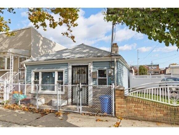
639 E 86th St, Brooklyn, NY 11236 Kings County Last Updated: March 13, 2024
Pre-Foreclosure: Lis Pendens, Estimated Market Value $464,000
Description: 639 E 86th St, Brooklyn, NY 11236 is a Single Family Home built in 1935. This property was last sold for $470,000 in 2008 and currently has an estimated value of $464,000. According to the Brooklyn public records, the property at 639 E 86th St, Brooklyn, NY 11236 has approximately 590 square feet, with a lot size of 800 square feet. Nearby schools include Ps 66, Ps 114 Ryder Elementary School, Explore Excel Charter School and Ps 276 Louis Marshall.
590 sqft
800 lot size
Year Built: 1935
Pre-foreclosure
639 E 86th St, Brooklyn, NY 11236
Last Updated: March 13, 2024
1
Single Family Home
Town House
Estimated Market Value EMV $ 464,000
639 E 86th St
bool(false)

bool(true)

bool(true)

int(0)
Estimated Market Value EMV $ 464,000
Foreclosure History
for 639 E 86th St
for 639 E 86th St
Type
Single Family Home
Town House
639 E 86th St, Brooklyn, NY 11236 is a Single Family Home built in 1935. This property was last sold for $470,000 in 2008 and currently has an estimated value of $464,000. According to the Brooklyn public records, the property at 639 E 86th St, Brooklyn, NY 11236 has approximately 590 square feet, with a lot size of 800 square feet. Nearby schools include Ps 66, Ps 114 Ryder Elementary School, Explore Excel Charter School and Ps 276 Louis Marshall.
Property features
Year Built:
Year Built:
1935
1935
Zoning:
Zoning:
R4-1
R4-1
Living Area:
Living Area:
590
590
Building Class:
A2
One Family Dwellings: One Story (Permanent Living Quarters)
Floors on Main Building:
1
Building Dimensions:
18'
Actual Square Footage:
590
Calculated Square Footage:
594
Residential Floor Area:
590
Address:
639 EAST 86 STREET
BIN
Name 639 EAST 86 STREET
Land Use:
01
One & Two Family Buildings
Calculated Lot Perimeter:
233.40 ft
Zoning Districts:
R4-1
Lower-density residence district
Max Residential FAR:
0.75
Max Residential Sqft:
600
Buildable Residential Sqft:
10
Residential Area Distribution:
Assessed Land Value:
$4,200
Assessed Total Value:
$27,780
Last Recording Date:
Jan 8, 2024
Property Assessment Data:
Tax Class:
1
One- to three-unit residential properties
Taxable Assessed Value:
$17,194
Estimated Market Value by NYC DOF :
$463,000
Community District (CD):
318
City Council District:
46
Document DateDocument Type Unit Amount
Date
Event
Price
Price/Sqft
Source
May 30, 2018
Listing removed
$299,000
—
REBNY
May 23, 2017
Listed
$299,000
—
REBNY
Aug 31, 2016
Listing removed
$210,000
$354
Brooklyn
Aug 31, 2016
Listing removed
$219,000
$369
Brooklyn
Feb 4, 2016
Listing removed
$299,000
—
RealPlus
Feb 25, 2015
Listing removed
$299,000
$507
Brooklyn
Nov 7, 2014
Listed
$299,000
$507
Brooklyn
Nov 6, 2014
Listed
$299,000
—
RealPlus
Sep 22, 2008
Sold
$470,000
$797
Public Record
Aug 24, 2007
Sold
$310,000
$522
Brooklyn
May 10, 2004
Sold
$405,000
$686
Public Record
Apr 23, 2004
Sold
$230,000
$390
Public Record
Jan 16, 2004
Sold
$125,000
$212
Public Record
Year
Taxes
Land
Additions
Total Assessment
2022
$3,213
$4,200
$19,980
$24,180
2021
$3,196
$4,200
$14,460
$18,660
2020
$750
$4,200
$16,140
$20,340
2019
$2,997
$4,200
$14,820
$19,020
2018
$2,937
$3,100
$10,940
$14,040
2017
$2,734
$4,030
$9,385
$13,415
2016
$2,530
$3,293
$9,363
$12,656
2015
$2,334
$4,680
$7,260
$11,940
2014
$2,287
$4,680
$7,260
$11,940
2013
$1,946
$4,680
$7,020
$11,700
2012
$1,815
$7,620
$3,960
$11,580
2010
$1,927
$7,508
$5,912
$13,420
2009
$1,870
$7,093
$5,809
$12,902
2007
$1,829
$1,987
$9,867
$11,854
Address
Price
Built
Beds
Baths
Sqft
Lot Size
Distance
9802 Avenue L
Brooklyn, NY 11236SF
$303,450
11/09/2023
1925
2
2
843
+253difference
2,375
0.92 mi
552 E 80th St
Brooklyn, NY 11236SF
$395,000
02/22/2024
1970
2
2
968
+378
3,000
0.37 mi
143 Branton St
Brooklyn, NY 11236SF
$400,000
12/18/2023
1940
2
2
1,020
+430
1,530
0.51 mi
981 E 94th St
Brooklyn, NY 11236SF
$700,000
02/21/2024
1940
3
2
1,097
+507
5,000
0.41 mi
9511 Flatlands Ave
Brooklyn, NY 11236SF
$440,000
01/12/2024
1930
3
1
1,176
+586
3,072
0.50 mi
8717 Glenwood Rd
Brooklyn, NY 11236SF
$675,000
02/29/2024
1965
3
3
1,980
+1,390
1,460
0.09 mi
939 E 87th St
Brooklyn, NY 11236SF
$555,000
04/26/2024
1920
3
3
1,224
+634
2,000
0.29 mi
610 E 79th St
Brooklyn, NY 11236SF
$635,000
01/31/2024
1960
3
2
1,260
+670
1,800
0.39 mi
9121 Avenue J
Brooklyn, NY 11236SF
$535,000
11/21/2023
1960
5
3
1,944
+1,354
2,829
0.44 mi
1302 E 91st St
Brooklyn, NY 11236SF
$690,000
12/12/2023
1955
3
2
1,368
+778
2,800
0.51 mi
Address
Price
Built
Beds
Baths
Sqft
Lot Size
Distance
1478 E 93rd St
Brooklyn, NY 11236SF
$449,900
47 days ago
1920
2
2
589
-1difference
1,226
0.83 mi
1433 E 52nd St Unit 3B
Brooklyn, NY 11234SF
$450,000
14 days ago
1965
1
1
640
+50
—
1.34 mi
919 Rockaway Ave
Brooklyn, NY 11212SF
$689,000
52 days ago
1987
3
2
1,126
+536
1,800
1.15 mi
Estimated values are not a substitute for professional expertise. Contact your RE agent for a market assessment.
School Name
Rating
Grades
Parent Rating
Distance
Our Lady Of Trust School
, Brooklyn , NY 11236
—
K−8
0.15 mi
Great Commission Christian School
, Brooklyn , NY 11236
—
K−7
0.39 mi
Ps 66
, Brooklyn , NY 11236
5 / 10
K−8
0.58 mi
Ps 114 Ryder Elementary School
, Brooklyn , NY 11236
8 / 10
K−5
0.21 mi
Brooklyn Community High School for Excellence and Equity
, Brooklyn , NY 11236
2 / 10
9−12
0.61 mi
Academy for Conservation and the Environment
, Brooklyn , NY 11236
5 / 10
9−12
0.61 mi
Brooklyn Bridge Academy
, Brooklyn , NY 11236
1 / 10
9−12
—
0.61 mi
First Impression Day Care Center
, Brooklyn , NY 11236
—
K−K
—
0.28 mi
Explore Excel Charter School
, Brooklyn , NY 11236
6 / 10
K−8
—
0.21 mi
Ps 276 Louis Marshall
, Brooklyn , NY 11236
5 / 10
K−5
0.50 mi
FEMA Zone (Est.)
X (unshaded)
Flood insurance:
Recommended
Flood risks are increasing as sea levels rise and weather patterns change.
This property has a
Minimal Flood Factor
.
Please Log In
Please wait... If this message is not eventually replaced by the proper contents of the document, your PDF viewer may not be able to display this type of document.
You can upgrade to the latest version of Adobe Reader for Windows®, Mac, or Linux® by visiting
https://get.adobe.com/reader/ this link .
For more assistance with Adobe Reader visit
http://get.adobe.com/reader/ this link .
You can download this PDF-document from
here .