
bool(false)

bool(true)

bool(true)

int(0)
Brooklyn, NY 11203
Foreclosure History
Property details
The description and property data below may have been provided by a third party, the homeowner or public records.
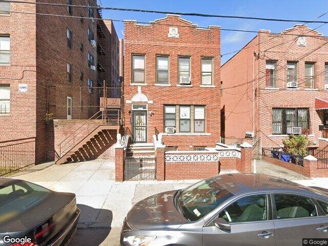
647 Winthrop St, Brooklyn, NY 11203 is a Multi Family Home built in 1931. According to the Brooklyn public records, the property at 647 Winthrop St, Brooklyn, NY 11203 has approximately 2,308 square feet, with a lot size of 2,600 square feet. Nearby schools include Achievement First Crown Heights Charter School and Ps 91 The Albany Avenue School.
Primary Land Use and Tax Lot Information
for 647 Winthrop St

Sold Homes
near 647 Winthrop St
| Address | Price | Beds | Baths |
|---|---|---|---|
|
Brooklyn, NY 11213MF
|
$1,085,000
02/26/2024
|
7
|
2
|
|
Brooklyn, NY 11203MF
|
$1,040,000
11/20/2023
|
6
|
3
|
|
Brooklyn, NY 11225MF
|
$1,300,000
02/27/2024
|
5
|
2
|
|
Brooklyn, NY 11225MF
|
$1,400,000
12/26/2023
|
5
|
3
|
|
Brooklyn, NY 11213MF
|
$1,030,000
11/16/2023
|
—
|
3
|
Schools
serving 647 Winthrop St
| School Name | Rating |
|---|---|
|
567 Kingston Avenue, Brooklyn, NY 11203
|
— |
|
739 East New York Avenue, Brooklyn, NY 11203
|
— |
|
790 East New York Avenue, Brooklyn, NY 11203
|
5 / 10 |
Data provided by
GreatSchools.org © 2024. All Rights Reserved.
School service boundaries are intended to be used as reference only.
To verify enrollment eligibility for a property, contact the school directly.
Flood Factor
for 647 Winthrop St
1
|10
Minimal

FEMA Zone (Est.)
X (unshaded)
Flood insurance:
Flood risks are increasing as sea levels rise and weather patterns change.
This property has a
Minimal Flood Factor
.
Although flood risks across the country are changing because of the environment, this property is unlikely to flood over the next 30 years.
Although flood risks across the country are changing because of the environment, this property is unlikely to flood over the next 30 years.
Flood Factor data provided by FloodFactor.