")

bool(false)

bool(true)

bool(true)

int(0)
Brooklyn, NY 11218
Foreclosure History
Property details
The description and property data below may have been provided by a third party, the homeowner or public records.
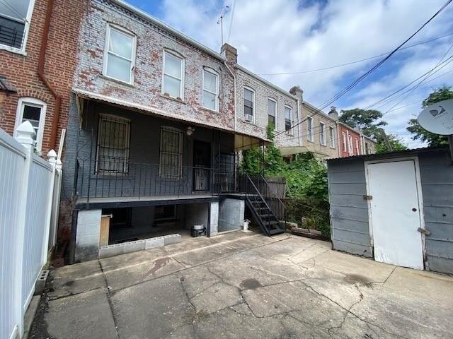
74 Kermit Pl, Brooklyn, NY 11218 is a Multi Family Home built in 1910. This property was last sold for $180,000 in 1994 and currently has an estimated value of $1,633,100. According to the Brooklyn public records, the property at 74 Kermit Pl, Brooklyn, NY 11218 has approximately 2,840 square feet, with a lot size of 1,600 square feet. Nearby schools include Ps 130 The Parkside and Ps 230 Doris L Cohen.
Primary Land Use and Tax Lot Information
for 74 Kermit Pl

Property Price History
for 74 Kermit Pl
| Date | Event | Price | ||
|---|---|---|---|---|
| Mar 21, 2023 | Listing removed | — | — | Brooklyn |
| Oct 7, 2022 | Price Changed | $1,674,000 | $589 | Brooklyn |
Property Tax History
for 74 Kermit Pl
| Year | Taxes | |
|---|---|---|
| 2023 | $7,159 | $107,700 |
| 2022 | $6,694 | $118,020 |
Sold Homes
near 74 Kermit Pl
| Address | Price | Beds | Baths |
|---|---|---|---|
|
Brooklyn, NY 11218MF
|
$2,150,000
05/05/2025
|
5
|
3
|
|
Brooklyn, NY 11218MF
|
$1,750,000
06/17/2025
|
8
|
6
|
|
Brooklyn, NY 11218MF
|
$1,800,000
06/24/2025
|
—
|
—
|
|
Brooklyn, NY 11226MF
|
$860,000
05/01/2025
|
5
|
3
|
|
Brooklyn, NY 11218MF
|
$1,400,000
02/26/2025
|
—
|
2
|
Homes For Sale
near 74 Kermit Pl
| Address | Price | Beds | Baths |
|---|---|---|---|
|
Brooklyn, NY 11226MF
|
$750,000
220 days ago
|
—
|
—
|
|
Brooklyn, NY 11218MF
|
$2,450,000
297 days ago
|
5
|
3
|
|
Brooklyn, NY 11215MF
|
$3,195,000
401 days ago
|
5
|
4
|
|
Brooklyn, NY 11226MF
|
$1,100,000
392 days ago
|
6
|
3
|
|
Brooklyn, NY 11232MF
|
$1,699,000
266 days ago
|
5
|
3
|
Home Value
for 74 Kermit Pl
Estimated values are not a substitute for professional expertise. Contact your RE agent for a market assessment.
Schools
serving 74 Kermit Pl
| School Name | Rating |
|---|---|
|
713 Caton Avenue, Brooklyn, NY 11218
|
5 / 10 |
|
500 Church Avenue, Brooklyn, NY 11218
|
— |
|
70 Ocean Parkway, Brooklyn, NY 11218
|
6 / 10 |
Data provided by
GreatSchools.org © 2025. All Rights Reserved.
School service boundaries are intended to be used as reference only.
To verify enrollment eligibility for a property, contact the school directly.
Flood Factor
for 74 Kermit Pl
8
|10
Severe

FEMA Zone (Est.)
X (unshaded)
Flood insurance:
Recommended
Flood risks are increasing as sea levels rise and weather patterns change.
This property has a
Severe Flood Factor
.
Flood Factor data provided by FloodFactor.